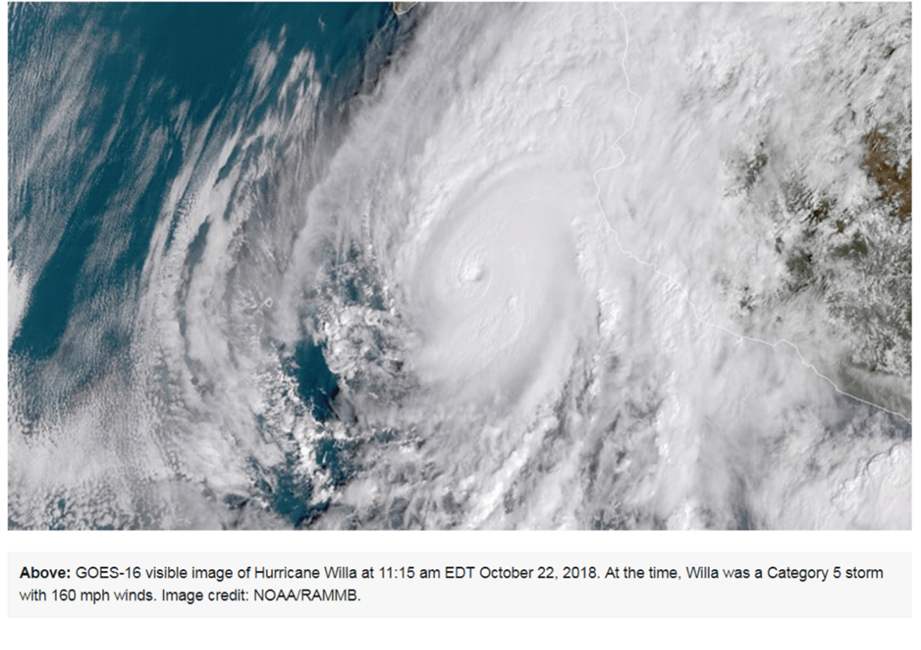
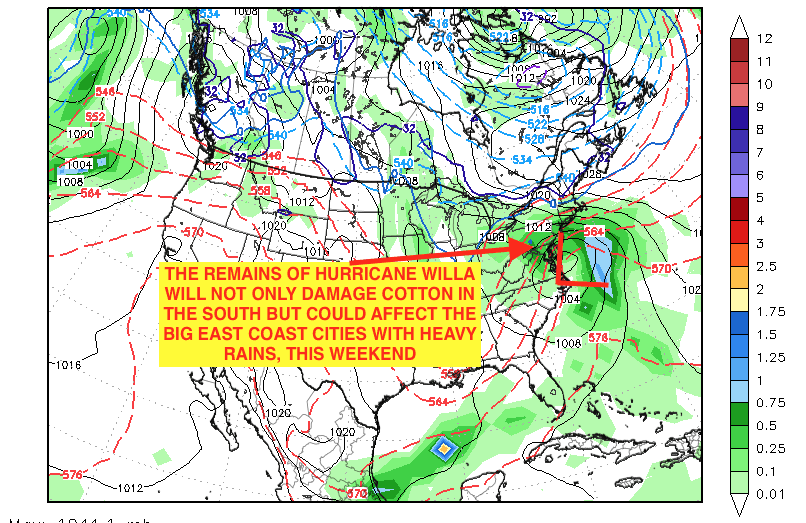
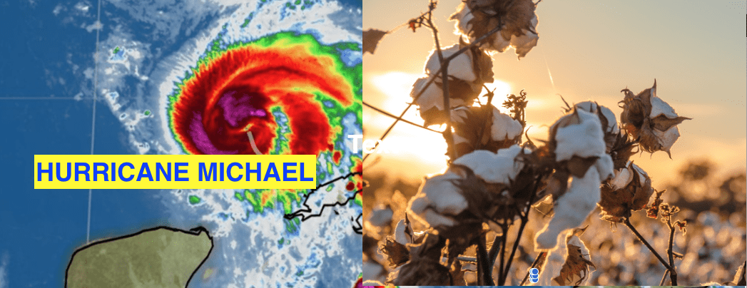
Hurricane Willa is weakening but will move into the Deep South and Texas the next few days further aggravating the US cotton crop. Its remains could then affect the big cities in the eastern U.S., which are having one of their wettest summers and falls on record. Typically, when the Pacific has an incredibly active hurricane season, the Atlantic and Gulf do not. This was one reason why earlier last spring, we initially felt the Atlantic hurricane season would be weaker than normal. However, Florence and Micheal, certainly put that scenario to rest.
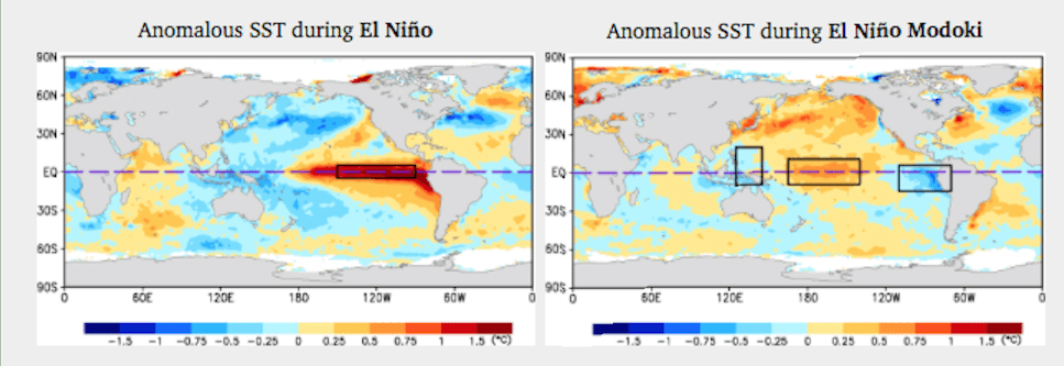
Not all El Nino’s are the same. The top map shows the difference in ocean temperatures between a standard El Nino and El Nino Modaki. There will be several potential big commodity trading opportunities in the months ahead. To find out which markets, from grains to soft and energy commodities will be most affected, and to receive future El Nino articles from us sign up for a free sample here.
Hurricane Willa
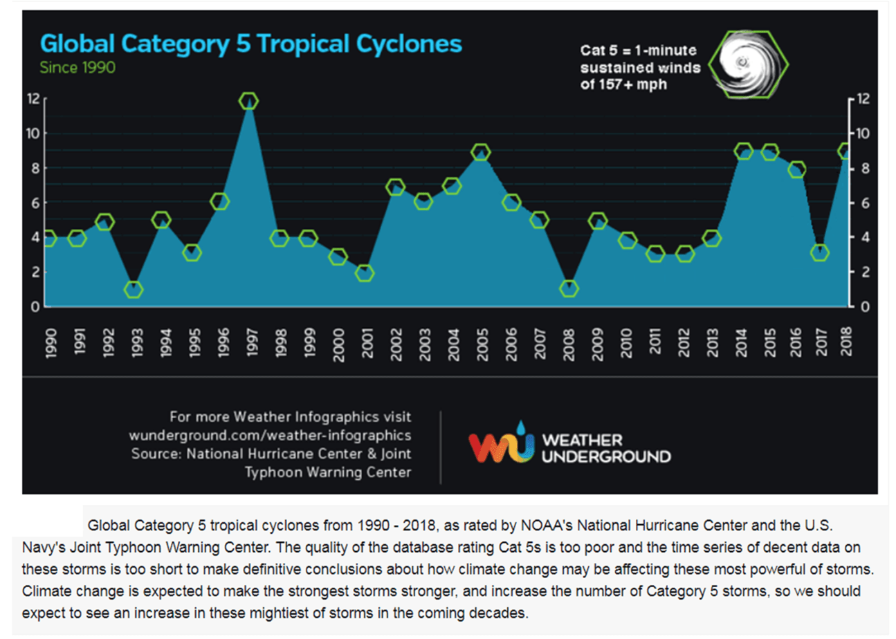
We have had a record number of category 5 hurricanes this year. Most of them in the central and eastern Pacific. This is due to global warming and also a sign that El Nino may be forming
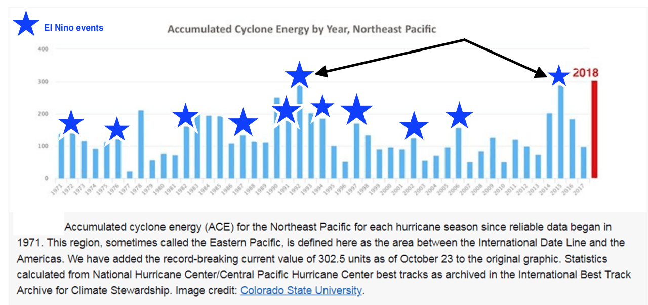
Cat 5 hurricanes
Total accumulated cyclone energy in the Pacific is the highest in history. The arrows point to two other developing strong El Nino’s (1997/2015) that followed similar, but slightly less active hurricane seasons in the Pacific.
Its Hot and getting Hotter: A case for Adaptive strategies for a warming planet
One of my missions in life, is not just to offer weather forecasting and advice in financial markets to farmers, hedge funds and traders around the world, but to “make a difference” on how man-kind treats our planet and takes measures to hopefully stop and adapt to global warming and climate change. I have had too many heated battles, and arguments with many people who to this day, still DISAGREE with me, that global warming is man-made and it is only a “cycle” that has repeated itself for tens of thousands of years. This “politicized” thinking, is absolutely ludicrous and “wrong” in not only my opinion but of more than 95% of scientists around the world. Creating a greener planet, for one thing, could create millions of jobs around the world!
The report below was written by Bob Bunting, a renowned scientist, meteorologist and entrepreneur, who lives here in Sarasota, Florida. The commentary I took from the article he wrote on behalf of Cumberland Advisors–a top, boutique, financial services company.
For more information about Bob and his newsletter, please see below.
As humanity contends with a hotter planet, more volatile weather, and higher sea levels, adaptive strategies offer a win-win approach for now and for the future. Where climate change is concerned, to fail to act is to plan to fail; but by proactively implementing adaptive strategies we can spur economic activity in the present, preserve property values and lifestyles, and help to ensure a viable future.
Back in the late 1970s and 1980s I was fortunate to be a scientist and executive at both NOAA and the National Center for Atmospheric Research, NCAR. During this period the signal on manmade climate warming emerged from the noise. The first global atmospheric climate model went into use at NCAR. The early runs with and without the impulse of greenhouse gases put into the atmosphere by humans produced stunning contrasts. Without human greenhouse gas inputs, the model forecast little change in global temperatures; but with the impulse from mankind, the climate forecast indicated a troublesome warming during the 21st century. From that time onward, people fractured into climate-warming advocates and deniers. Led by remarkable consensus among scientists worldwide, the climate-warming forecast has seeped into the collective consciousness.
The NY Times Magazine recently featured a comprehensive review of what happened in Washington during the climate-warming realization period prior to 2000. The article detailed how and why the opportunity to limit climate warming was missed. At the time, many perceived a dramatic rollback of the carbon footprint of humans as hurting the US and other developed economies while simultaneously allowing developing counties to continue dirty development with old carbon-producing technologies.
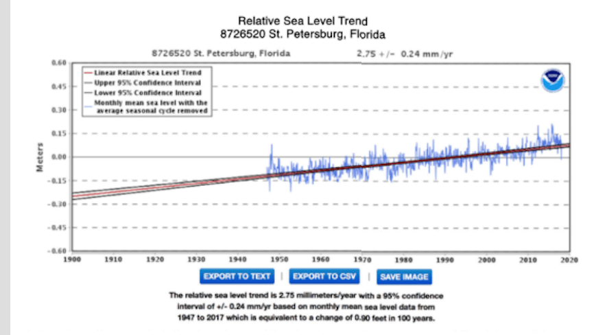
Realizing that this difficult tradeoff was unlikely to be adopted, NCAR leadership began promoting the adaptive idea that climate warming presented a great economic opportunity for a technology-rich America and other advanced Western countries. Imagine developing India and China, whose goal was to turn the lights on for a few billion people, receiving cleaner-burning power plants and other more efficient technology from the West, thereby leapfrogging past their existing and soon-to-be-built dirty, high-carbon/high-sulfur coal power plants. Given the present state of affairs in 2018, it is clear this adaptive message fell on deaf ears! We can’t undo the past, and significant global warming is already baked into our future, so where can we go from here? Our message of 40 years ago is still the most effective one I have heard. Climate warming is not a theory but an unfolding reality. We estimate that the global temperature has increased about 1.1°C, or about 2°F, since 1880; and sea level has risen approximately 10 inches.
Humankind can best deal with the consequences of climate change in an adaptive way that limits losers while maximizing winners. The imperative of slowing down, ending, and/or mitigating greenhouse emissions has received all the headlines. Meanwhile, unfortunately, the adaptive message has been lost. In addition to curbing emissions, we need to prepare for climate change that is already in the process of happening. I hope to move your thought in the direction of adaptive strategies because these strategies put us on the critical path to lasting solutions. But before we move forward, we need to grasp where we are now in the climate-warming scenario.
In the face of the rises in both global temperature and sea level, we continue to debate what is causing the global changes we have observed. The troublesome truth is that anthropogenic climate change is underway, and limiting additional greenhouse gas inputs from CO2, nitrous oxide, methane, etc. is critical to limiting the magnitude of the warming over the next few centuries. Even if miraculously the world could stop carbon emissions today, the Earth would continue to warm, and sea levels continue to rise until at least 2060. By then our children and grandchildren will be as old or older than we are now! It is in the best interest of our generation and the next few generations to focus on adaptive measures that can mitigate many of the impacts that we see now and that will increase over time. Humans must learn to address longer-term threats posed by climate change and act to protect future generations.
Adaptive strategies are at least part of the answer. For those of us living along the coast, managing sea level rise, for example, could well preserve our way of life now and for the next 50 years and probably beyond. We can, for example, preserve the value of our real estate, limit insurance premiums, and enhance the enjoyment of our adult and/or senior years. These and other benefits make adaptation personal and align with human instincts of self-interest and preservation.
Think, too, about the economic opportunities for small and large businesses that provide the adaptive solutions we need. Using the coastline as a continuing example, coastal engineers will design shoreline protection against additional sea level rise; providers will make or deliver materials to selectively harden and soften the shoreline to manage the rise and buffer more frequent and dangerous storm surges; consultants will help government on local, regional, and national levels to bridge the gap between need and implementation. We know that 80% of the world’s 7.5 billion people live close to the shore, and in Florida alone $6T of real estate is on the beach!
Moving inland, agriculture is likely to be an area where adaptation will pay large returns as the climate warms. The grain belts are located in many interior regions of the major continents. The US grain belts in the Midwest and plains, for example, will probably endure more frequent droughts and changes in the prime growing season. Drought, if not countered by adaptive strategies, could result in lower average crop yields. Adaptive strategies could include adjustments of planting and harvesting dates, changes in crop varieties, planting drought-resistant plants, separating fields with windbreaks, intermingling plots for grazing with those for planting, and developing alternatives for crop insurance.
I could go on, because there are hundreds of adaptive strategies in many economic segments that would mitigate the worst impacts of likely climate changes while enhancing economic activity. This is why I predict that adaptive climate change mitigation will become one of the fastest-growing and most lucrative business categories of the 21st century. We ought to help business see this opportunity and catalyze it for everyone, and the sooner the better!
So what is holding us back? One thought is that scientists necessarily present a range of outcomes and not precise forecasts, given the many uncertainties of making long-range predictions. The result has been a range of outcomes from 2°C to 6°C in temperature rise and 8 inches to 6.6 ft. of sea level rise by 2100. Given this large range, the impact could be quite manageable (but still significant) at the low end of the range and catastrophic at the upper end.
If you take away only one thing from this missive, it should be this. By 2100 the most likely range of temperature rise is, in my opinion, an additional 1.2–1.5°C rise in temperature and about 10–14 inches of further sea level rise. In order to reach these numbers, the current rate of sea level rise will have to advance from about 1 inch every 10 years to double that rate over the next 50 years. While these numbers are not pleasant, they portend real-world impacts that can be managed if we stop arguing about whether climate change is natural or manmade and start acknowledging that either way, the climate is warming and sea level is rising now.
It isn’t productive to wait for a 100% consensus as to the reasons for climate change. In the limited sense, who cares why? We all need to care about and address the adverse impacts no matter who or what is responsible. We buy insurance all the time for outcomes that are far less certain than climate warming and sea level rise. This is the message I have carried to business leaders, local government officials, and national congressional leaders in my sphere of influence. You can help by doing the same!
Bashing the media is not my intention, but the media becomes part of the problem when they hawk worst-case and least-probable scenarios. Sensationalizing promotes fear and creates a “deer in the headlights” syndrome that results in inaction. Showing, for example, how NYC could be underwater in 50 years without also classifying such an occurrence as about a 1% probability event is not helpful. Headlines presenting the worst-case and lowest-probability scenarios are both devastating and depressing because they tend to delay implementation of adaptive strategies. When people feel they have no options because they are going to be underwater, they are more likely to flee rather than to adapt. While climate warming has a fat-tail risk that should not be ignored, that risk also shouldn’t be the driver of paralysis that it has become.
If, however, the most likely scenario is presented, i.e., one with, say, an 80% chance of happening, society would be encouraged to move forward and to maintain our assets and lifestyle by taking adaptive measures. It is vitally important that we switch gears now while we still have affordable and viable options. It isn’t too late!
A final piece of the puzzle is quite encouraging. Knowledge is advancing at such a rapid pace that 50 years from now we may well have ways to sequester carbon and reverse climate warming. In my short lifetime, I have witnessed an incredible and increasing rate of change in human knowledge and technological progress, as I am sure you have. The knowledge tsunami is accelerating and is a cause for great hope and an affirmation that it isn’t too late.
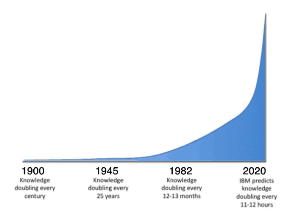
Buckminster Fuller introduced his knowledge-doubling curve in 1982, about the same time as climate warming became a worldwide concern. With the help of IBM, the curve was modified and is shown below.
I don’t have the data to show exactly where we are on the knowledge curve today, but I think the overall point is well made. Adaptation to climate warming and sea level rise is not a hopeless activity. It is as necessary part of a wider solution that is sure to come as our knowledge grows exponentially. We can and must give humankind the chance to solve the climate crisis. We need to get to work now on doing just that by implementing adaptive strategies! Please bring this message forward, and I hope you will!
Bob Bunting is a scientist, entrepreneur, educator and the author of a financial newsletter at bobsstocks.com.
Cumberland Advisors Market Commentaries offer insights and analysis on upcoming, important economic issues that potentially impact global financial markets. Our team shares their thinking on global economic developments, market news and other factors that often influence investment opportunities and strategies.
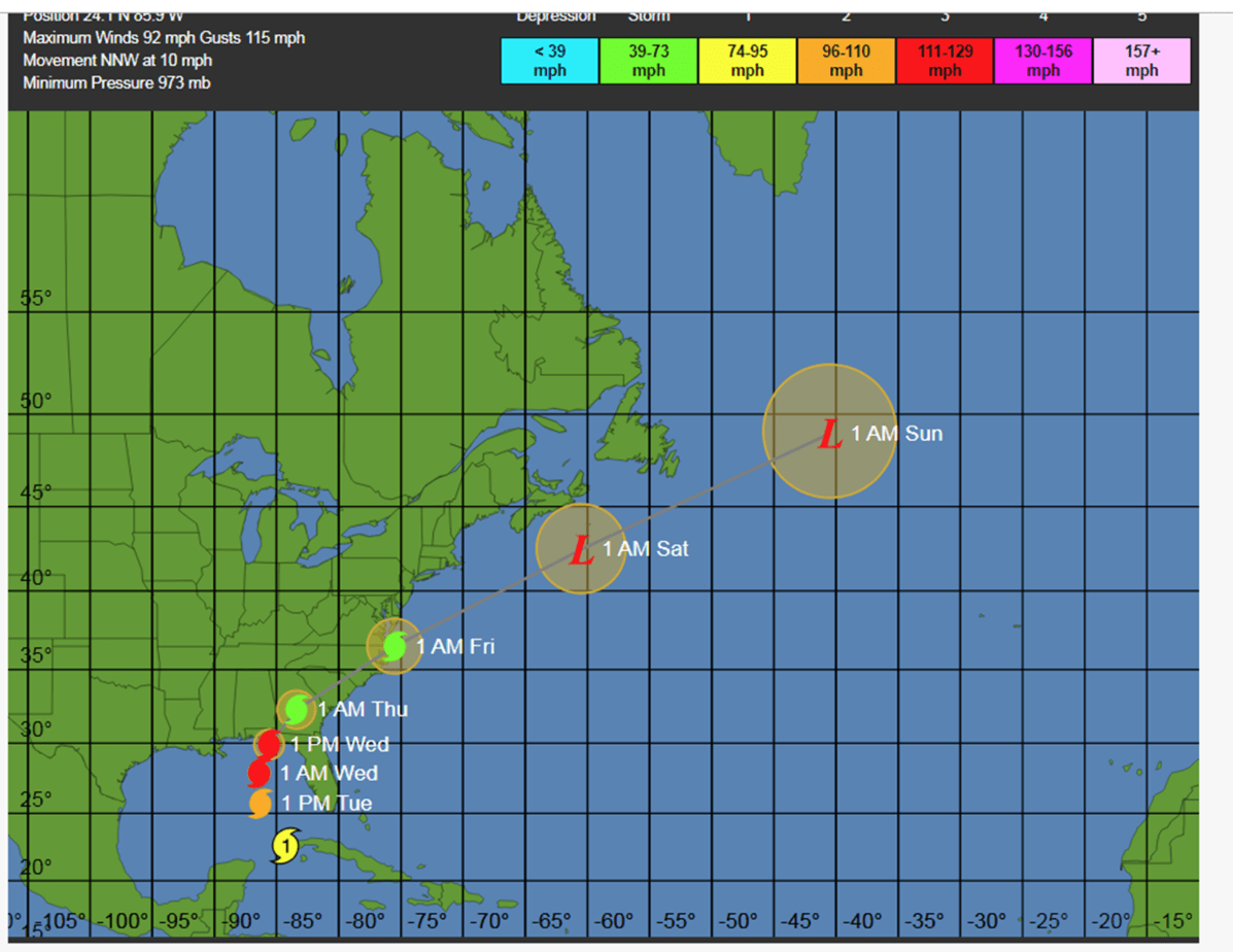
Hurricane Michael was gathering strength on Tuesday it entered the southeast Gulf of Mexico, en route to an expected Wednesday landfall on the northeast Gulf Coast. A hurricane warning was in effect for the entire upper Florida coastline from the Suwanee River westward, with the Alabama coast in a hurricane watch. Storm surge watches and warnings extended further to the east, because of the surge-producing characteristics of the Florida coast and remaining uncertanties in Michael’s exact strength and track.
The storm is expected to become a category 3-4 hurricane before it hits land.
A damaging storm surge for the Florida Panhandle and Big Bend is expected for the northeast Gulf Coast of Florida from the Okaloosa/Walton County Line to Anclote River. This warning was bracketed by storm surge watches westward to the Alabama border and southward all the way to Anna Maria Island, including Tampa Bay.
There are very shallow waters along the coast where Michael is expected to make landfall, where the continental shelf extends out about 70 – 90 miles from shore. The winds from the storm will thus be able to pile up a large storm surge along the east side of the storm’s center. When this surge rides ashore at landfall, the water may reach heights of 8 – 12 feet in Florida’s Apalachee Bay—part of the Big Bend region between the Florida Panhandle and the southward-jutting Florida Peninsula—since the concave-shaped coast there acts to concentrate storm surge.
When Category 3 Hurricane Dennis made landfall in the western Florida Panhandle near Santa Rosa Island in July 10, 2005, it brought a storm surge of 6 – 9 feet to Apalachee Bay, which lay 170 miles east of Dennis’s landfall location. The surge inundated parts of the town of St. Marks and other nearby areas. A storm surge of 4 – 6 ft occurred elsewhere in the Florida Panhandle.
High tide is between 12:30 – 1 am on Wednesday and Thursday at Pensacola, FL. There is only one high tide per day in the Gulf, and the difference between high tide and low tide is just over one foot. The high tides in the Gulf this week will not be increased by the fact that the new moon occurs on Monday. This is unlike the situation along the Southeast U.S. coast, whsere the new moon will bring the king tides—some of the highest tides of the year. Because of the king tides and the onshore flow of air affecting the Southeast U.S. coast from Michael, we are likely to see moderate coastal flooding in Charleston, SC during high tide Tuesday through Wednesday.
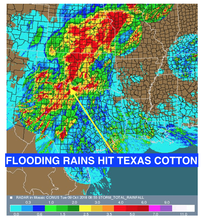
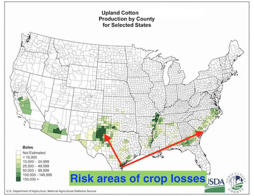
The report below explains why Michael has formed, and can strengthen even more than some models suggest, by mid week. This is in contrast to my earlier feelings last May and June that a major hurricane would probably NOT hit the Gulf coast this season. The report also highlights why the U.S. cotton crop will be hurt by heavy rains, not only in the Southeast U.S. but also in Texas, something we alerted clients to quite early.
(some of the information above are excerpts from weather underground.com)
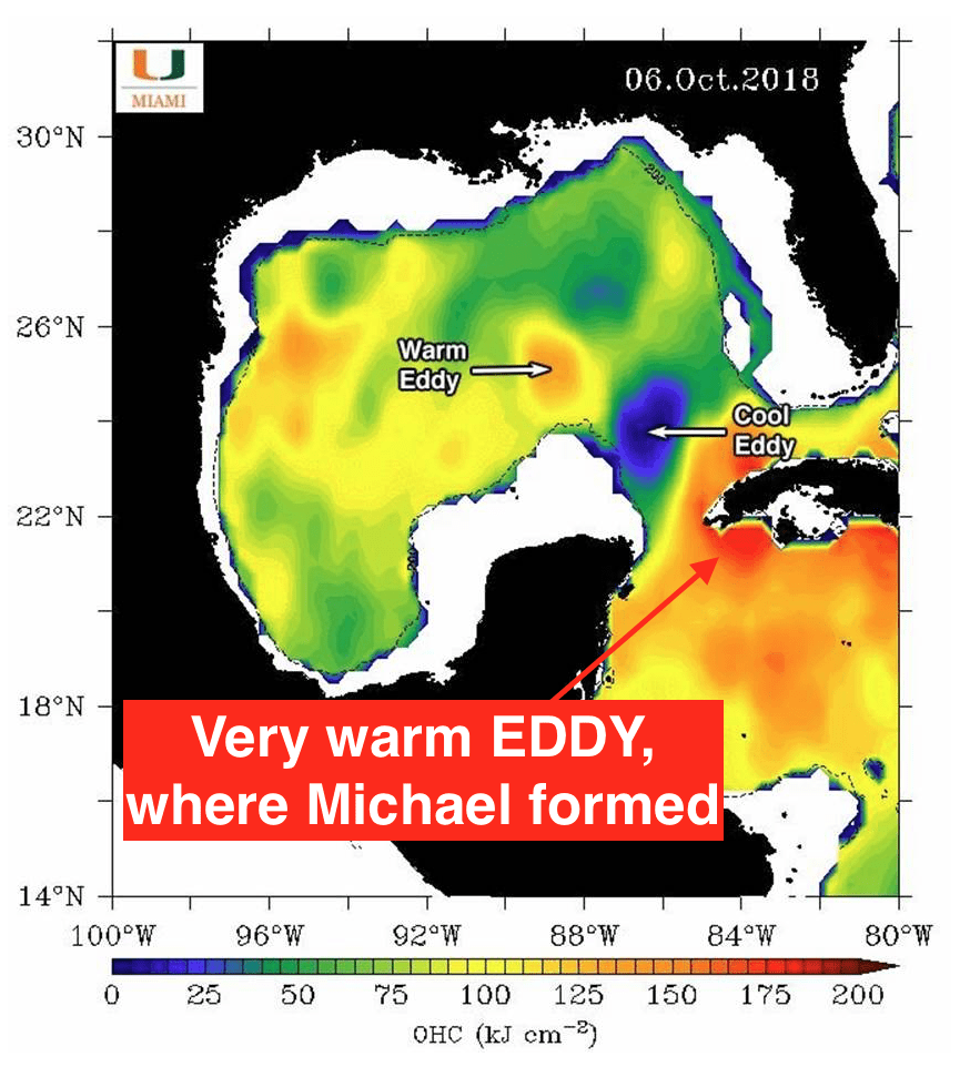
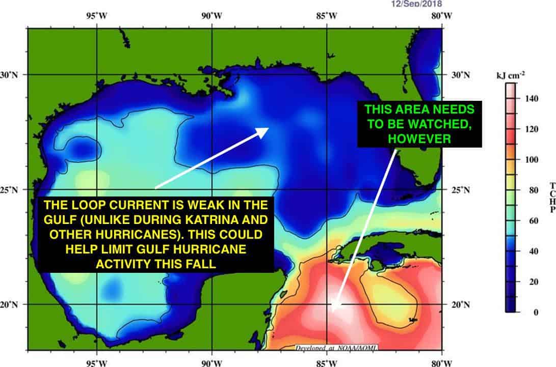
How the Loop current affects Gulf coast tropical formation
Hurricane Michael
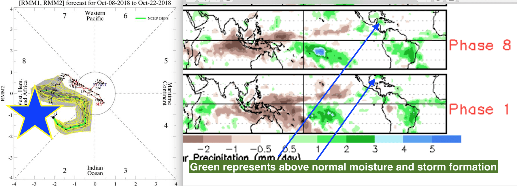
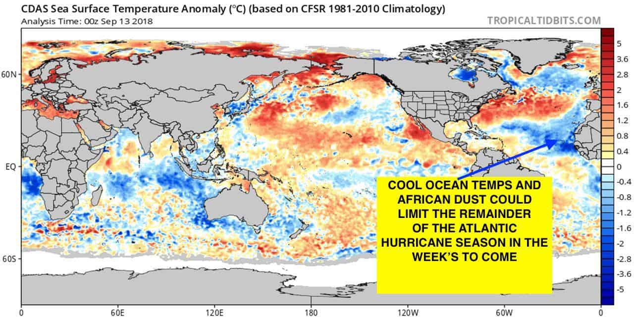
Back in May and June we discussed a weaker than normal hurricane season. This was due in part to cool ocean temperatures off the coast of West Africa and also a possible formation of El Nino. As it turns out, waves off the west coast of Africa, which normally impact the hurricane season through October, have indeed been weaker than normal. Though Florence brought catastrophic flooding to the Carolina’s, up until Hurricane Micheal, there has NOT been a major strike of a hurricane in the U.S. this summer or fall. The warming climate, which has strengthened the LOOP current in the Gulf of Mexico, plus perfect timing of the MJO in a phase 8/1 are the reasons Michael formed out of nowhere. A good explanation of the LOOP current is here.
Loop Current
The MJO and its influence on hurricane development
TheMJO (more info here)is a tropical wave phenomenon that can influence the weather thousands of miles away. It has been known that the MJO in phases 8, 1, 2 (eastern Pacific and western Atlantic) can enhance cyclonic activity and sometimes tropical storms. The combination of the warm Gulf Coast LOOP CURRENT, described above and the perfect timing of the MJO in these active storm phases, helped to form Michael. This is in contrast to a potential forming El Nino and cool ocean temperatures off the coast of Africa, that helped us forecast a less active hurricane season than 2017, last May and June.
MJO
Could the cotton market see more upside potential on weather issues?
The cotton market has been in the dog house for two months, mainly because of worries over Trade War Tariffs against China, but also a huge net long position in the market that has resulted in technical selling. However, our weekly Climatelligence newsletterbecame a bit more friendly this market a week ago on worries about too much rains in west Texas, a possible reduction in the India or Pakistan crop from minor weather issues and an oversold situation. Now with hurricane Micheal affecting the harvest in key states of Georgia and South Carolina, cotton prices have bottomed, for now. However, often weather related bullish cotton moves on hurricanes is short-lived.
Nevertheless, how the U.S. harvest fares over the next few weeks could have an impact in the cotton market. Most recently, we have seen an explosion in coffee futures, natural gas and other commodities, which we pointed out could happen. Join the dozens of enthusiastic commodity traders and farmers that have sampled or subscribed to our unique new newsletter here.
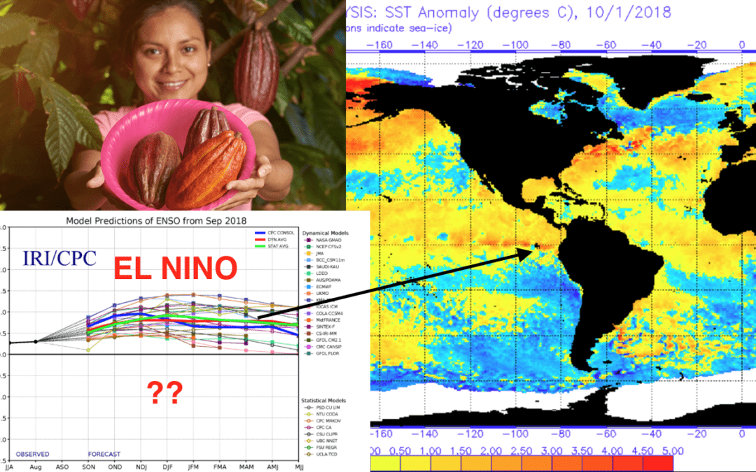
Have coffee and cocoa prices bottomed as El Nino possibly forms? Our Climatelligence Report recently began discussing a likely low in coffee prices last week and that the Brazilian Real might soon break out to the upside (see here a sample). While sugar, coffee and soybeans often follow the movement in the Brazilian Real, there are also potential global weather problems developing for “some commodities.”
After a day of one of the most bullish moves in commodities in months, there has also been talk of El Nino forming more quickly than anticipated. This helped some markets, like cocoa, rebound following a recent major collapse on good global crops and technical selling. Cocoa is one of the most actively bullishly traded commodities when El Nino is present. Though NOT all El Nino’s are the same. Our forecasts in coming weeks will be critical to many markets, not just cocoa.
Will El Nino be a serious threat to cocoa and other commodities in the months ahead? How can you trade weather related markets and get the best first hand weather information, and market sentiment, often before markets react. Subscribe here for a 25% discount.
Below, I talk briefly about what traders are looking at with regards to El Nino, or not. NOAA, the Japan Meteorological Center and others suggest a 55-65% chance of El Nino during the northern hemisphere winter. Until recently, I was of the belief that as we head into a period of low solar activity, the chances for El Nino tend to be weak. However, there is some conflicting research which suggests otherwise that low solar activity increases the odds of El Nino. I will write an article on this within the next few weeks.
By the way, natural gas prices are breaking out on the lowest supplies since the 2005 Katrina hurricane season. El Nino, or not, will affect this market in a big way come winter
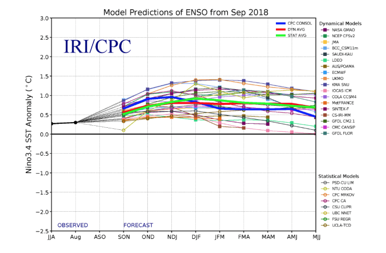
Computer models are not always right and have, at times, been over-zealous in their forecast of El Nino or La Nina, but you can see the warmer than normal ocean temps forecasted by all models
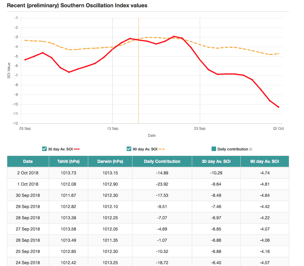
The SOI index is just as important as warm ocean temperatures around the equator with respect to El Nino. The SOI index tanking was one reason for coffee and cocoa prices rallying on the “psychology” of potential weather problems. What is the SOI index? It has to do with surface pressure differences between Darwin, Australia and Tahiti Click here
SOI index
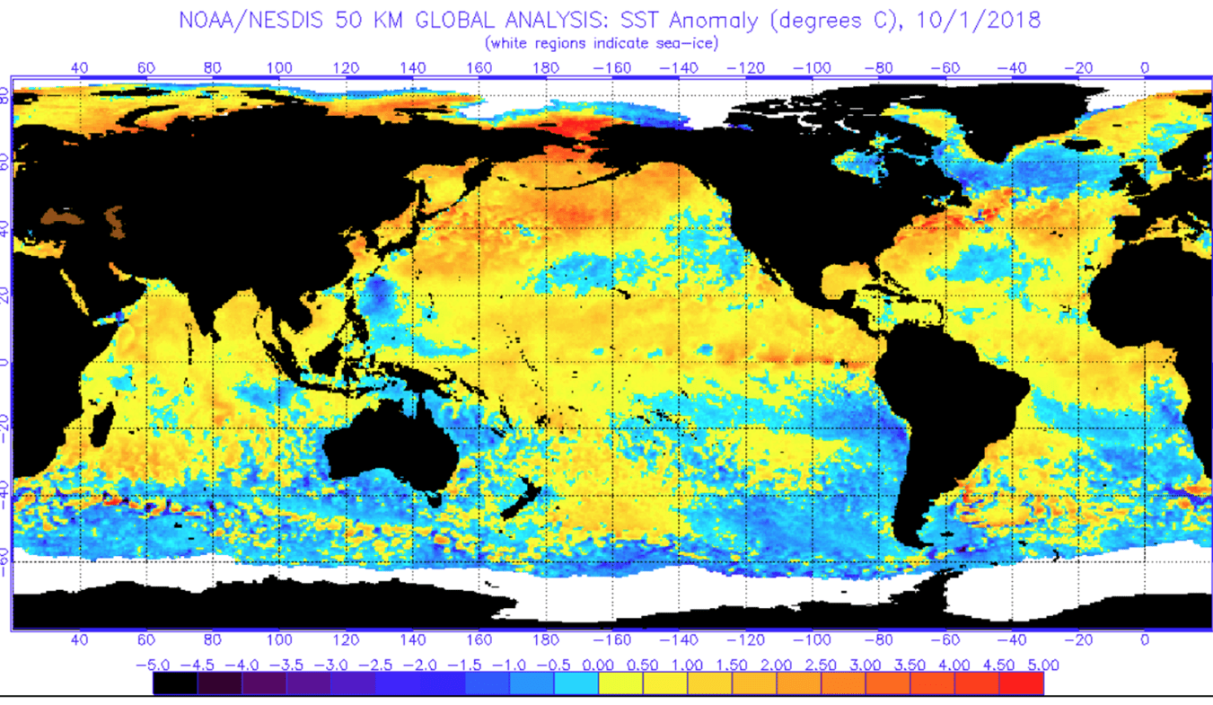
Warming ocean temperatures along the equator is beginning to suggest a great chance for at least a weak El Nino by this winter
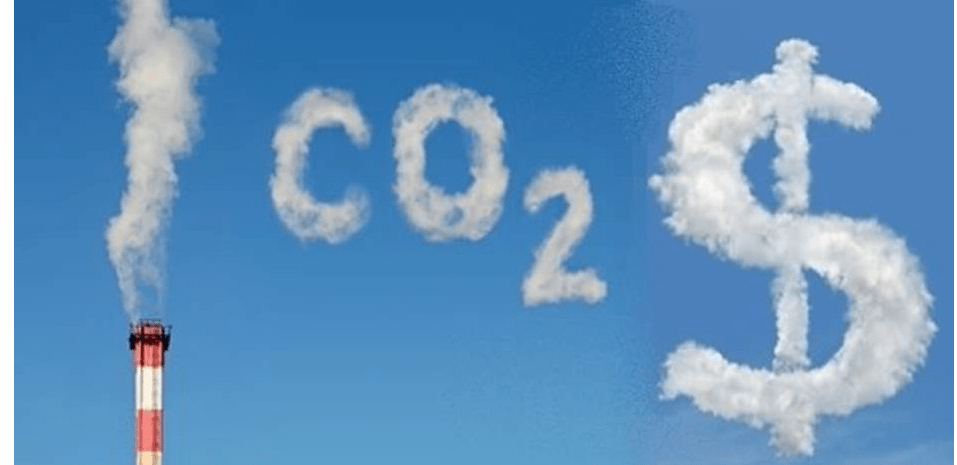
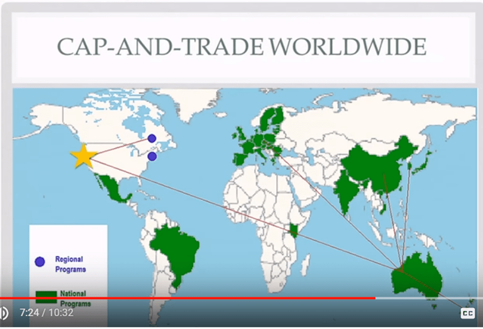
Richard Sandor created the Chicago Climate Exchange and “Cap and Trade” (emissions trading) helped to commoditize carbon and other chemicals that have ruined our environment. Clean water and clean air are the most important commodities to protect as we head deeper into the 21st century.
The price of carbon has soared this year as carbon trading mechanisms begin to take off. Climate change has never been higher on the agenda and yet the world is still struggling to find the best way to resolve this serious issue. Acceptance is growing with regard to carbon trading to clean up the environment. For a recent article about carbon trading click here
In April of 2010, the Intercontinental Exchange (ICE), a leading operator of regulated global futures exchanges, clearing houses and over-the-counter (OTC) markets announced terms to acquire the Chicago Climate Exchange.
Social and environmental objectives can be reached with financial incentives. See a TedTalk (below) here from Dr. Sandor.
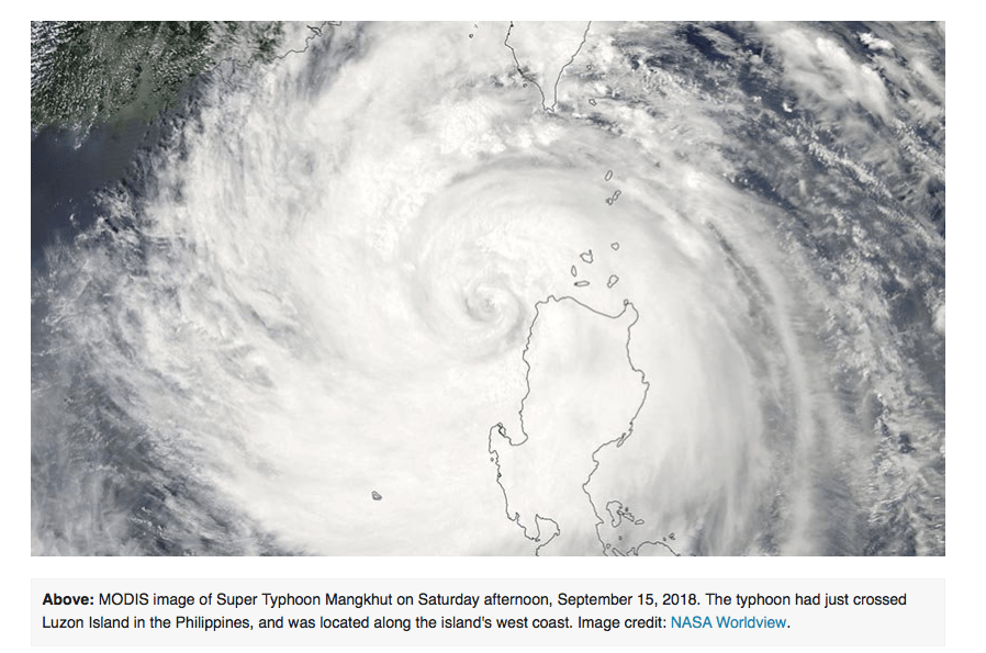
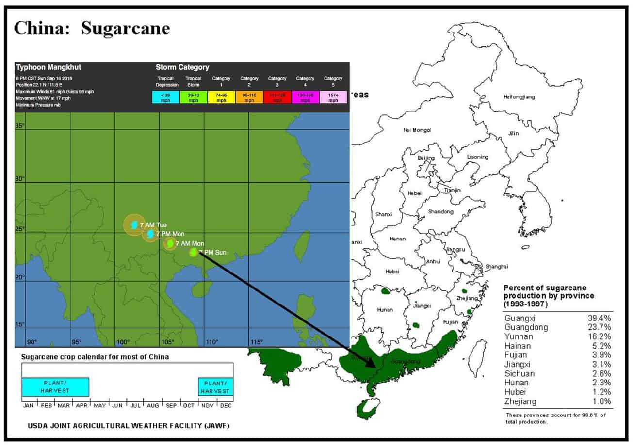
Typhoon Mangkhut barreled into the island of Luzon in the Northern Philippines early Saturday as a Category 5 hurricane with 165 mph winds, killing at least 16 people. Mangkhut brought extreme rains to the Philippines, with western Luzon picking up more than 26 inches of rain on Saturday. Mangkhut is the Thai word for mangosteen fruit, is known as Ompong in the Philippines. Mangkhut was initially a a Category 5 storm with 180 mph winds, making it Earth’s strongest storm so far in 2018.
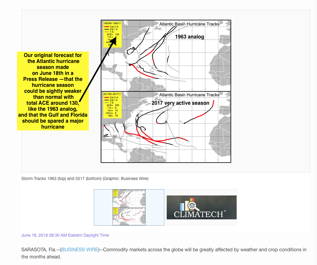
FORECASTING A WEAKER ATLANTIC AND GULF HURRICANE SEASON
While Hurricane Florence brought deadly floods to the Carolina’s, the combination of cool ocean temperatures in the eastern Atlantic, our CLIMATECH research, months ago, and the active Typhoon season near Hawaii, the Philippines and south China, all portend to us that the Atlantic hurricane season will tame down in the week’s ahead.
You can see a Press Release here we did last June on why we thought the 1963 analog might be a good fit for this season’s hurricane activity. That particular year had several Atlantic hurricanes and some close to the east coast of the United States, but nothing major for Florida or the Gulf coast.
Shares in China’s major sugar producers jumped on Monday as investors worried supplies of the sweetener could be affected by the super typhoon. However, according to several sources, the impact was not that severe to sugar crops. Sugar growing areas in China are located in Zhanjiang, which is a major sugar producer in Guangdong province.
Will weather problems in Brazil, Europe and India be possible for sugar crops in the weeks ahead? Find out by subscribing to our unique commodity weather newsletter and get special reports for multiple commodities. Get a free sample here
HELPING YOU MAKE THE BEST INVESTMENT DECISIONS BASED ON THE WEATHER
We use cookies to ensure that we give you the best experience on our website. If you continue to use this site we will assume that you are happy with it.