Cold weather is affecting energy markets. After a normal to warm early December, our original winter forecast for cold weather is coming to fruition with temps in the Midwest expected to be as much as 10-15 degrees below zero the next few mornings. But will it last and what is the future for energy prices? That is only for subscribers to find out.
Natural gas and heating oil prices have taken notice. In addition drought expanding in the Plains will have to be watched in the coming months for an explosive move in wheat prices after 5 years of a bear market. Climatech, our long range in house software program, looks at global teleconnections. These include ones such as La Nina, arctic temperatures and weather trends thousands of miles away. It has accurately predicted, months in advance the cold end to December across the U.S. Notice the average 3 month forecast for eastern Australia (wet), South American corn and soybean crops (not a drought) and west African cocoa.
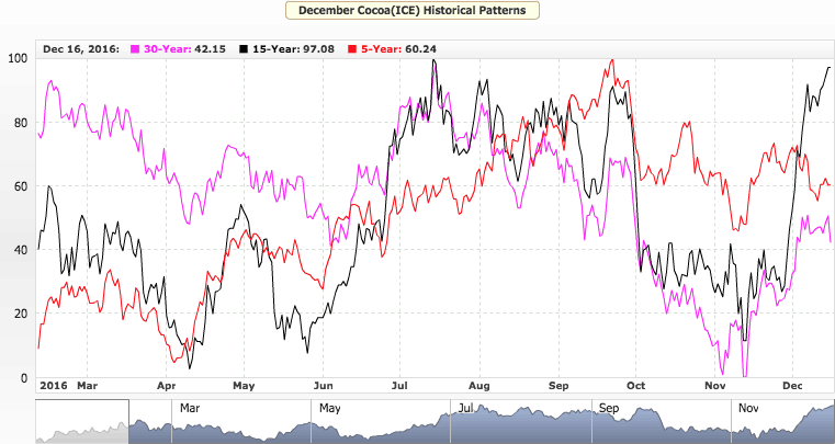
Cocoa crops globally will continue to benefit. This was a main reason why, over the last year, cocoa prices have fallen more than 50%.
Jim Roemer’s Climatech–Above we show how the warm Atlantic and La Nina signal result in average rainfall projections for the next 3 months. Notice the wet signal in eastern Australia through March. Also, generally good conditions in South American for soybeans and good weather in west Africa for cocoa. The blue represents (In inches) above normal rainfall the next 3 months. For more information about how you can DEMO this amazing long range weather forecast program. Please email us at
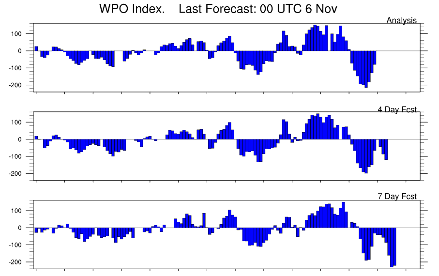
As La Nina forms, and the oceans cool in the equatorial Pacific, winters tend to start out mild for the most eastern ski resorts and the majority of U.S. energy areas, but there are exceptions. 1995 and 1985 were two La Nina events that had a huge block over the NW part of Alaska to the arctic circle. The strong block, or negative Western Pacific Oscillation Index is just one feature that can result in cold weather and will influence natural gas and perhaps heating oil trading in the weeks and months ahead.
The colder outlook has helped natural gas prices soar through resistance, but any short to longer term weather forecasts is only reserved to paying clients. subscriptionsbestweather@gmail.com
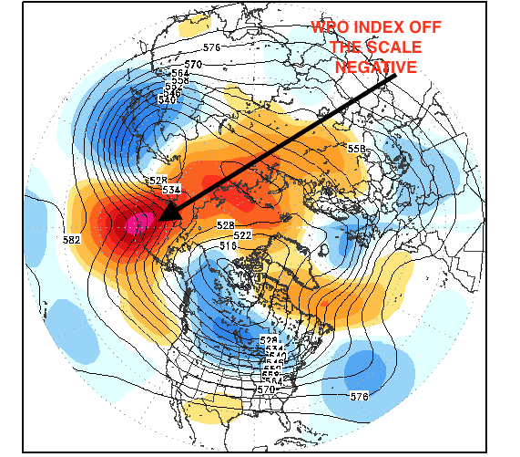
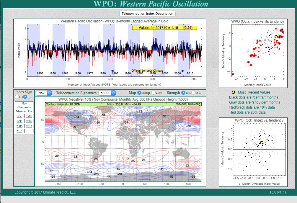
Another important factor to the northern Hemispheric winter is the NAO. Many of you have heard about this index. When there is a warm block over Greenland and the NAO is negative, severe cold and snows can invade the Northeast U.S. and/or Europe. Below we show our proprietary in house software Climatech http://climatepredictanalytics.com and how the WPO index in November can actually forecast a negative NAO. This increases the odds of a cold early start to the winter with lots of fireworks in the energy markets. But how to trade these kind of markets and any changes in the WPO/NAO relationship is only reserved, again, for paying clients.
MAP ABOVE WWW.STORMVISTA.COM
CLIMATECH’S NEGATIVE WPO INDEX——NOTICE THE WARM (RED BLOCK) OVER GREENLAND AND POTENTIAL NEGATIVE NAO
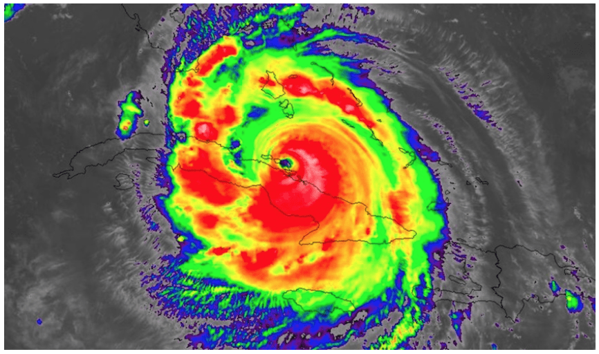
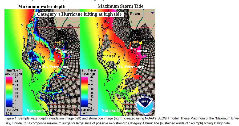
The hurricane center and many others helped Florida officials to evacuate the eastern part of Florida, originally. We began discussing quite early Thursday night, a much more western track of Irma. While the Miami area and the east coast of Florida still see coastal flooding and some detrimental effects from Irma, it is really the west coast of the State that may take the brunt. Models have been too far east for days and hence, Irma has a chance to stay out over the water and move towards Ft Meyers or Sarasota. Hence, a CAT 4 hurricane at landfall near Ft. Myers or near Sarasota early Monday a.m, is a distinct possibility. The video also discusses “possible” wind shear that could weaken Irma in time before it does catastrophic damage in western Florida, but confidence is LOW on this, due to the warmer waters.
CLICK ON THE LINK ABOVE TO LISTEN
Longer range weather forecasting, which is our strength for the commodity and financial industry, is often easier than short-term forecasting. However, I have been calling quite often the last couple days, for more of a western track of Irma than many other firms, etc.
As of early this afternoon Saturday, Irma was downgraded to a category 3 storm as it brushed the coast of Cuba. However, I expect it to become a cat 4 or cat 5 storm again due to the warming waters, which has accelerated over the years, due to global warming. The video on youtube above also shows how our proprietary software long-range weather forecast program CLIMATECH, predicted a hurricane season as bad as 2005 (Katrina, etc), and 2010, back in June
The month of May was a tough one for portfolio managers in Australia. The S&P 200/ASX fell >2.5% from April highs. The banking industry was mentioned as a potential reason for the sell off. Moody recently downgraded the major Australian banks’ credit ratings from Aa2 to Aa3 due to the mortgage risk they have (over 60% of loans are in residential property). Check out this Bloomberg article for more info:
Another reason for the sell off could have been the lower exports of iron ore over the past year. Cyclone Debbie disrupted production and it had a ripple affect on the economy over the past few months. The storm damaged rails when it hit the northeast shore in early April.
The bright side of the past year has been the agriculture sector. The Australian Bureau of Statistics stated that the sector grew 27% in 2016. This is expected to continue, with wheat, canola, sugar and especially cotton leading the way. Now, however, below normal rainfall may threaten crop production, and thus the Australian economy.
Drought Potential
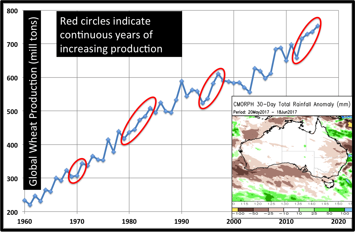
There is talk of drought moving forward for Australia, most notably in the cotton regions in the east. The past 30 days have been slightly dry, (10-50mm below normal). Wheat needs to be planted soon, and requires adequate moisture to do so. Cotton farmers need not worry for a few months. Global wheat production has risen 5 straight years. Australia will need more rainfall to help this trend continue.
Rainfall will become even more important later, from August through December. The major concern is the potential for El Niño conditions during this period. Warmer waters in the equatorial Pacific create greater descent over the Australian continent.
In addition to the El Niño impacts, the Indian Ocean can also affect Australian rainfall patterns. When the Indian Ocean Dipole is in a positive phase (current state), the western Indian sea surface temperature anomalies are warmer than those in the east. This set up usually leads to below normal rainfall over Australia. The questions moving forward are: Will a moderate El Niño form and will +IOD conditions persist?
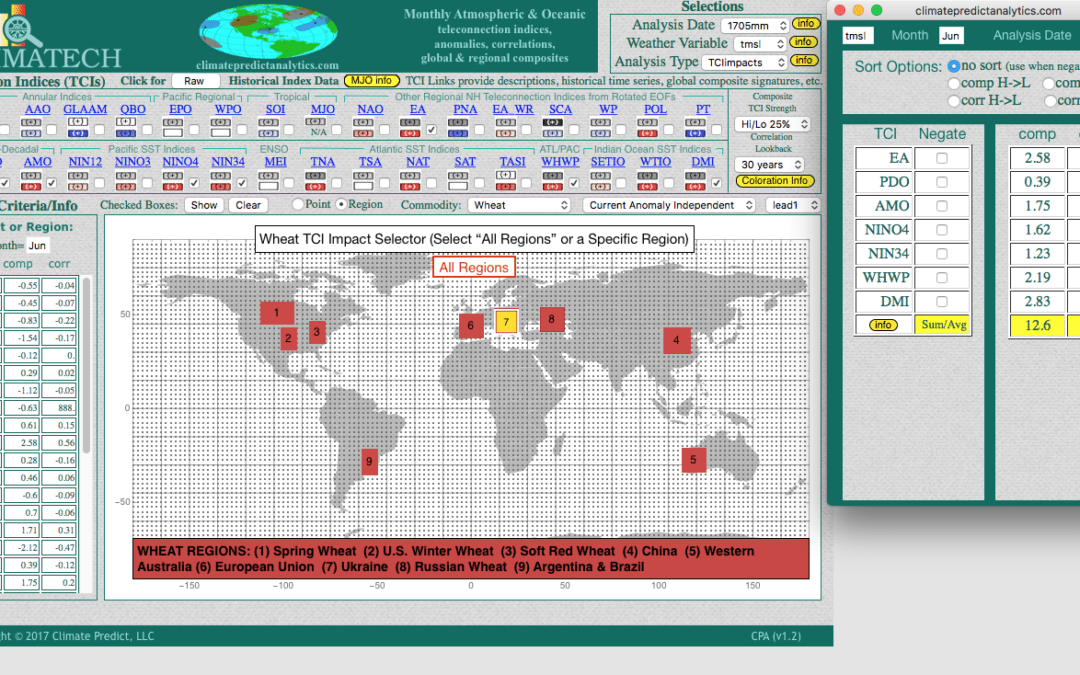
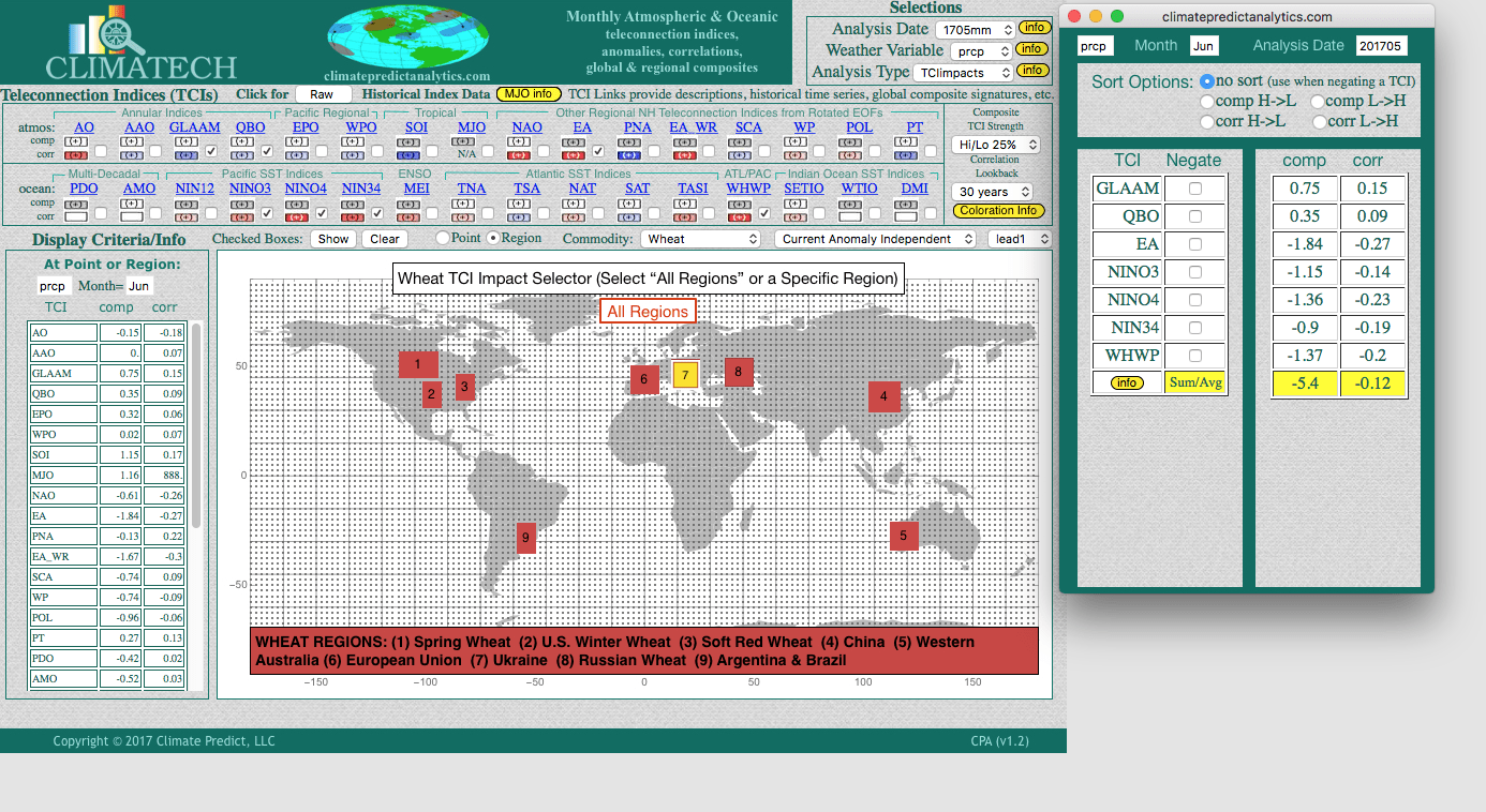
CLIMATECH above shows (7) areas in Europe that could have a hot June and potential crop stress next month. In combining the most important global teleconnections, notice how in some areas, the prediction is for temperatures in Europe to be as much as 12.6 degrees above normal
Wheat prices have been in the doldrums for years. However, a lower U.S. crop brought on by reduced acreage and the potential for continued severe weather and flooding that may lower wheat quality, could keep prices from falling very far.
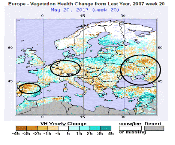
At the same time, we are seeing the vegetative health index turn a bit dry in parts of Europe and Russia. While not a disaster yet, our exclusive CLIMATECH program is predicting areas of warmth and dryness in some European wheat areas next month based on various teleconnections around the globe.
Areas of dryness (orange and red), need to be watched (above). If we have other weather issues around the world, other than wet U.S. weather hurting some crops, then wheat prices would take note
The best long-range weather forecasting tool in the industry, you can get a FREE demo but going to the web site Climatech, Shown below is our June forecast for below normal rainfall in parts of Europe due, not just to pre-El Nino conditions ,but a host of other global teleconnections.
We mentioned to clients a few weeks ago that a heavy short position in the cocoa market, combined with potential “psychological concerns” over a developing El Nino, has probably meant a bottom was in for the cocoa market (at least for now). Political unrest in west Africa combined with areas of dryness (red on map, below) in parts of Ivory Coast and Ghana are reasons for this short covering rally? Will this continue? Subscribers to our newsletter will find out the answer in the months ahead (https://www.bestweatherinc.com/climatelligence/).
Political unrest in Ivory Coast is also helping this market, but usually a reaction in cocoa is over-done with regard to political issues.
In the meantime, heavy rains have hit parts of Nigeria and Cameroon, in which transportation has been stalled for days due to muddy roads.
Combine all of this factors, and we have seen nearly a 10% rally in cocoa the last couple weeks. The Key Point right now is, that it is probably a bit late to jump on board going long cocoa, until more is known about El Nino (or not) and what summer through winter weather will be.
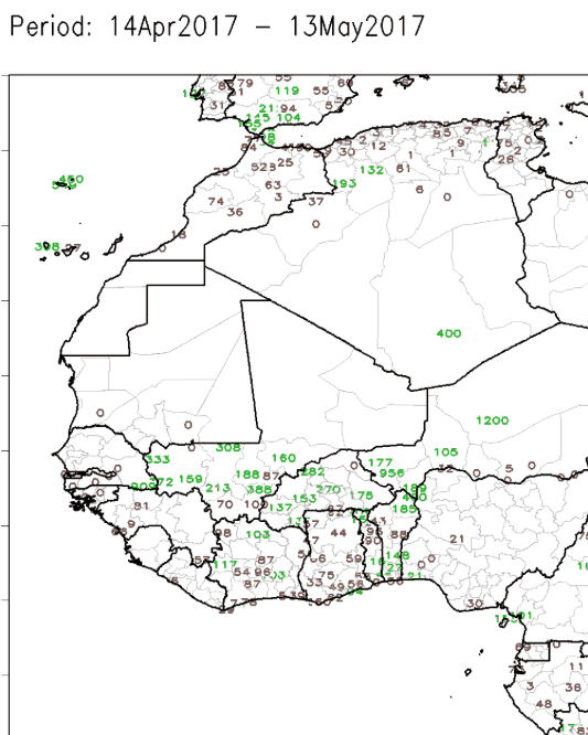
RAINFALL (ABOVE) THE LAST MONTH IN WEST AFRICA—TOO DRY IN PARTS OF IVORY COAST AND GHANA NEEDS TO BE WATCHED. THIS IS NOT A BIG FACTOR IN LOWERING PRODUCTION YET, BUT HEAVY RAINS IN NIGERIA AND CAMEROON IS AFFECTING TRANSPORTATION OF BEANS
HELPING YOU MAKE THE BEST INVESTMENT DECISIONS BASED ON THE WEATHER
We use cookies to ensure that we give you the best experience on our website. If you continue to use this site we will assume that you are happy with it.OkPrivacy policy