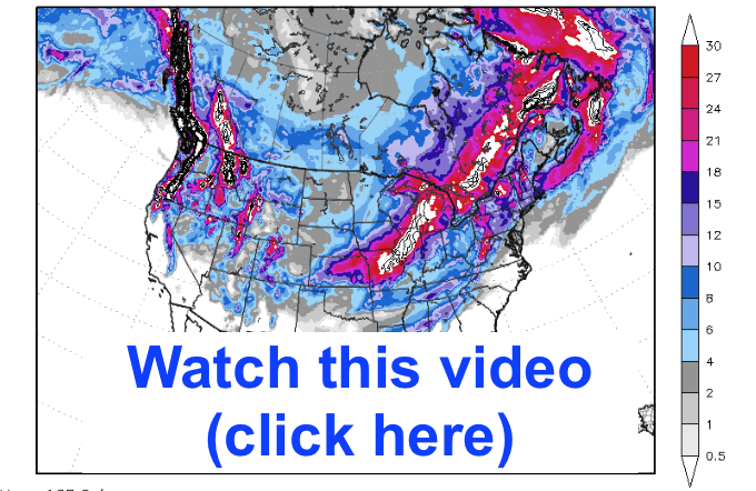
A negative NAO index has to do with a warm block near Greenland. (please watch my video —it explains how this is affecting commodities)
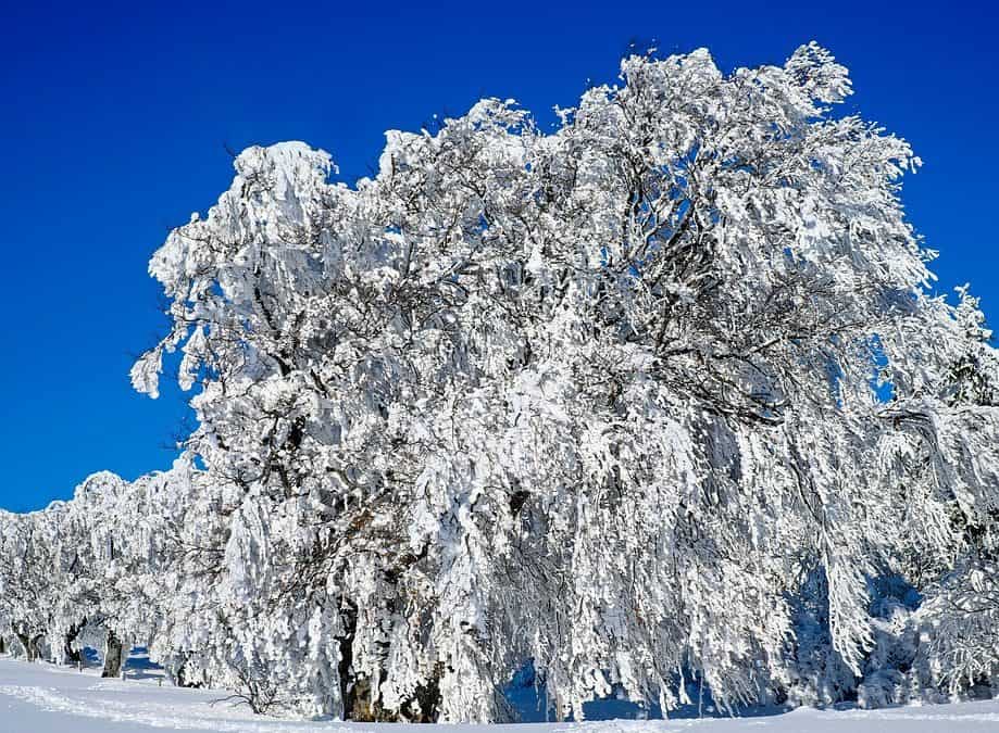
SNOWFALL PROJECTIONS NEXT 2 WEEKS (INCHES): A negative NAO will bring many areas in red and white over 1-2 feet of snow from at least 2 major storms. The most snowfall in several years
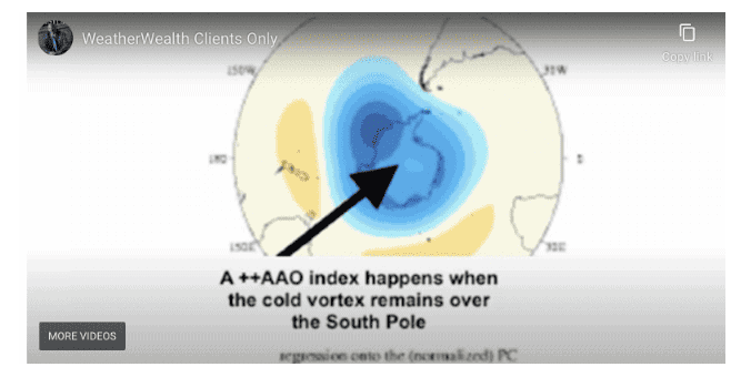
The opposite is happening over the South Pole (Antarctica), there has been a positive AAO index. This means the vortex stays put and does not move north. Combined with El Niño, this has brought improved weather for South American soybeans, something I alerted all my WeatherWealth subscribers about, three weeks ago.
Only 4 or 5 El Niño events have seen a powerful negative NAO index in January. Most of these years saw El Niño weaken by the spring or summer. Based on this scenario, this will be very important for many agricultural markets, and I will be developing trading strategies in options, futures, and ETFs.
How a negative NAO (warm block over Greenland that forces the Polar Vortex south) affects commodities:
1)Energy/Natural Gas: Coldest weather in at least 2-3 winters coming for Europe and the U.S. starting next week
2) Wheat: Isolated areas of winterkill in Russia and possibly Nebraska and big cold and snows for the southern Plains and Midwest. It will be important to monitor snowfall.
3) Cocoa: While I was bullish all summer and autumn long on major wet weather and disease issues, the lack of a Harmattan Wind in Ivory Coast and Ghana could prevent any further damage to the cocoa crop
How does a positive AAO index (The vortex that remains over Antarctica and does not move north) affect commodities?
1) Soybeans/Corn: Easing of the northern Brazil drought and potential big Argentina crops
2) Coffee: A hot November and early December likely will lower Brazil’s coffee production by several million bags, but improved rainfall is on the horizon that will stop further damage.
Join farmers and traders worldwide who want an advantage in trading agricultural and energy futures with over 100 issues a year of WeatherWealth with frequent weather updates and trading ideas. Download a recent complimentary issue here about El Nino https://www.bestweatherinc.com/new-membership-options/
This free report below was written three weeks ago before we changed the weather forecast for natural gas and energy markets)
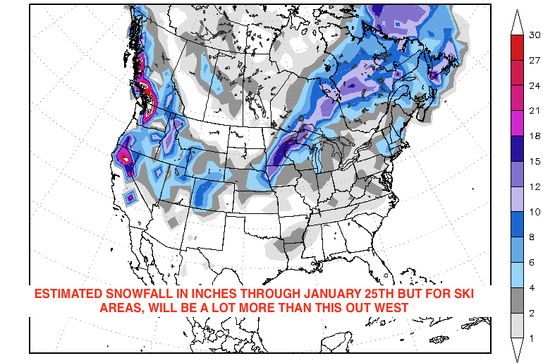
Map from CWG/Stormvista.com. All comments from Jim Roemer
The map above shows estimated snow (inches) through January 25th . However, given my experience forecasting weather for ski areas for 25 years, I can tell you that much of the Sierras, Cascades, Colorado and Utah ski areas will see at least 2-3 feet over the next 10 days or so—Jim Roemer
The huge blue trough you see out west will continue to break the western drought but bring more mud-slides to parts of California as well as feet of snow to the west through the end of January.
This season’s feeble ski season from Colorado to Utah and California. This is about to change
The report below is a week old, but interesting nevertheless: a lot of snow has fallen in the western ski areas over the last week with tons more coming. More information about the ski season and historical information on snowfall can be found from the great site www.bestsnow.net and Tony Crocker.
BESTSNOW.NET 2017-18 Ski Season Progress Report as of January 8, 2018:
October 2017 snowfall was strongest in the higher elevations of western Canada and the northern Rockies with some lesser amounts in Colorado. First half of November snowfall was high in the Pacific Northwest and inland northern regions, resulting in some early openings and deep snowpacks. There was also an atmospheric river storm mid-November in California. Thanksgiving week brought widespread rain to 9,000 feet to the northern regions, degrading the snowpack at lower elevations. Thanksgiving snowpacks were still over 4 feet at Mt. Baker, Whistler and Grand Targhee.
The farther south you go, the less November snow there was, and some opening dates were pushed back. The western US was under severe sustained high pressure for the first half of December. The week before Christmas brought substantial snow to the Northwest and spread inland to the Rockies as well. Northern Utah and Colorado got a couple of feet but still endured limited holiday skiing similar to 2011-12 and are unlikely to reach full operation before February.
The Southwest still has almost no natural snow on the ground and should be avoided indefinitely barring major dumps. Skiing in other regions acquired an adequate snowpack at higher elevations in November. Lower elevations had a lot of November rain, resulting in variable coverage and surfaces. But the week before Christmas snow brought most Northwest, western Canadian and northern Rockies area into midwinter form. These regions also got a foot of snow Christmas week.
The first week of January saw up to a foot of snow over most of the West, refreshing surfaces but not enough to open much more terrain. Most forecasters believe there will be substantial storms during the second half of January.
California:
An early November storm only snowed more than a few inches north of Lake Tahoe and over 8,000 feet. The second week’s storm was much bigger though also snow mostly over 8,000 feet. Mt. Rose got 4 feet and Mammoth got 2+ feet at its Main Lodge snow plot but 5+ feet up top. Thanksgiving week had a bit of rain followed by warm weather resulting in spring conditions. A foot of snow in late November restored surfaces to the areas with an adequate base over 8,000 feet. With less than a foot of December snow, Mt. Rose and Mammoth continued to have the best skiing, but ungroomed snow was bumpy with more obstacles over the holidays.
Other Tahoe areas have marginal base depths around 2 feet on limited terrain, have been beaten up by holiday crowds and should be avoided until there is much more snow. Early January snow was a foot at Mammoth but mostly rain at Tahoe. A current similar storm is expected to be twice as big and should bring Mammoth close to full operation. See Current California Ski Conditions for more details on Southern California and Mammoth.
Area
Season Snow
Pct. of Normal
Pct. of Area Open
Squaw 8,000
68
42%
23%
Alpine Meadows
46
36%
22%
Mt. Rose
84
69%
78%
Heavenly
47
34%
26%
Kirkwood
52
31%
71%
Mammoth
50.5
40%
71%
Southern Cal
0
0%
0-48%
Arizona Snowbowl
4
5%
33%
Pacific Northwest:
The region had some October storms but the rain/snow line was above all but the alpine sectors of Whistler and Mt. Bachelor. First half of November snowfall was widespread and many areas opened by November 18. The Thanksgiving week rain reduced the Mt. Baker and Whistler base depths from 6 feet to 4 feet. Base depths elsewhere were reduced to the 2 foot range. Late November snow improved surfaces and restored about a foot of base lost by the rain.
Much of the Whistler alpine opened Dec. 9 after extensive avalanche control, resulting in twice as much open terrain as anywhere else in North America. The Northwest had a scattered foot of snow during the first half of December but in the second half of December it dumped 3 feet at Mt. Hood, 4 feet at Whistler and 5+ feet inWashington State areas. New Year’s base depths were 4-5 feet at most areas, 6 feet at Whistler and 8 feet at Mt. Baker. There was little snow in early January but about 2 feet is expected this week.
Area
Season Snow
Pct. of Normal
Pct. of Area Open
Whistler
201
111%
100%
Crystal Mt.
184
110%
88%
Stevens Pass
156
79%
100%
Mt. Hood
118
64%
75%
Mt. Bachelor
100
63%
46%
Canadian Rockies and Interior B.C.:
Snowfall was abundant in this region from late October through mid-November. Thanksgiving week rain affected the Okanogan and Kootenay areas, though base depths declined only at Fernie, remaining near 3 feet at most other areas. With 2+ feet of snow in late November/early December, base depths reached the 3-4 foot range. Second half of December snowfall was a bit under 2 feet around Banff but 4+ feet in the Okanagan and Kootenay regions. Base depths are 4-5 feet and this remains the best overall ski region entering the new year. Silver Star and Sun Peaks were 2/3 open by mid-December and in full operation for the holidays. There was little snow in early January but about a foot is expected this week.
Area
Season Snow
Pct. of Normal
Pct. of Area Open
Big White
120
97%
98%
Lake Louise
112
152%
95%
Sunshine
144
138%
89%
Revelstoke
170
108%
70%
Kicking Horse
171
153%
96%
Whitewater
146
91%
100%
Red Mt.
90
80%
87%
Fernie
155
101%
70%
Castle Mt.
176
161%
93%
U. S. Northern Rockies:
Grand Targhee had 115 inches snowfall by mid-November, and thus opened 82% on Nov. 17 and 100% by Thanksgiving. Interior Northwest areas got the rain and December 1 base depths were in the 2+ foot range. Most areas got a little under a foot of snow in early December before the high pressure set in. Second half of December snowfall of 5 feet brought excellent holiday skiing to Schweitzer, Whitefish and the interior Northwest. Southern Montana and the Tetons got 3-4 feet, bringing Big Sky to 90% open. Overall this region was close to full operation for the holidays on 3-5 foot bases, except for Sun Valley which only had 3 inches of December snow. There were a few inches of early January snow with a foot expected this week, more at the interior Northwest areas.
Area
Season Snow
Pct. of Normal
Pct. of Area Open
Grand Targhee
191
101%
100%
Jackson Hole
142
92%
69%
Bridger
122
106%
100%
Schweitzer
165
144%
100%
Brundage
88
71%
100%
Sun Valley
47
59%
53%
Utah:
Utah had minimal October snow and was on the edge of November storms. Some opening dates were delayed and any skiing is on limited snowmaking. An early December storm dropped up to 18 inches in the Cottonwood Canyons, a foot at Snowbasin and 6 inches in Park City, but only a little bit more terrain opened. After only a few inches here and there in mid-December, the Wasatch got 2+ feet just before Christmas, but holiday open terrain and season snowfall still fell just short of 2011-12 and were the lowest since 1980-81. Terrain remains limited after a few inches last week, but may improve with 1-2 feet possible this week. Utah probably needs 4+ feet more snow to get close to full operation.
Area
Season Snow
Pct. of Normal
Pct. of Area Open
Alta
81
40%
75%
Snowbird SNOTEL
69
38%
22%
Brighton/Solitude
70
37%
65%
Park City (mid estimate)
48
43%
20%
Snowbasin
72
61%
59%
Brian Head
22
19%
23%
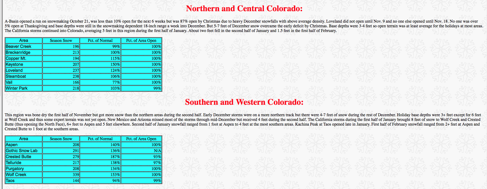
Northern and Central Colorado:
A-Basin opened a run on snowmaking October 13 followed by Loveland on October 20. November snowfall was about half average and all skiing was on a manmade base of no more than 18 inches. A-Basin is 36% open. First half of December snowfall averaged about one foot. The Northwest storm track finally hit at Christmas with 2+ feet from Steamboat through the Continental Divide with less at Vail and Beaver Creek. However, as of New Year’s only Steamboat and Winter Park were more than half open, with most areas only slightly better off than in 2011-12. Vail had less open than any New Year’s since 1980-81. With a few inches last week and about a foot predicted this week it will probably take well until February to for most of these areas to approach full operation. Open terrain now is similar to mid-December of an average season.
Area
Season Snow
Pct. of Normal
Pct. of Area Open
Beaver Creek
48
38%
38%
Breckenridge
84
68%
52%
Copper Mt.
68
68%
39%
Keystone
74
84%
58%
Loveland
81
66%
31%
Steamboat
90
63%
83%
Vail
58
42%
27%
Winter Park
98
73%
79%
Southern and Western Colorado:
This region has been driest of all so far with no end in sight, so all skiing is on limited snowmaking. The Rocky Mountain Biological Lab at Gothic (between Crested Butte and Aspen) had 17 inches in October and 55 inches since, the total being the lowest in 44 years of records. Even Wolf Creek has had just 58 inches (28 of it during the first week of November) and reports 90% open but on a sketchy 19 inch base.
Taos is 14% open. Aspen/Snowmass has similar conditions as the northern and central areas above. Farther south, the first two months of the season were so dry (the Christmas storm was 1.5 feet at Aspen and Crested Butte but less than a foot farther south) that these areas should be avoided before mid-February at the earliest. Advanced terrain is unlikely to be open before then unless there are major dumps. Taos’ Kachina lift and much of Crested Butte’s North Face, needing substantial snowpacks on steep terrain, are in danger of not opening at all this season. Last week’s snow was a few inches and about a foot is predicted this week.
Area
Season Snow
Pct. of Normal
Pct. of Area Open
Aspen/Snowmass
51
56%
36%
Gothic Snow Lab
55
42%
N/A
Crested Butte
47
52%
35%
Telluride
26
27%
16%
Purgatory
26
27%
24%
Wolf Creek
58
40%
90%
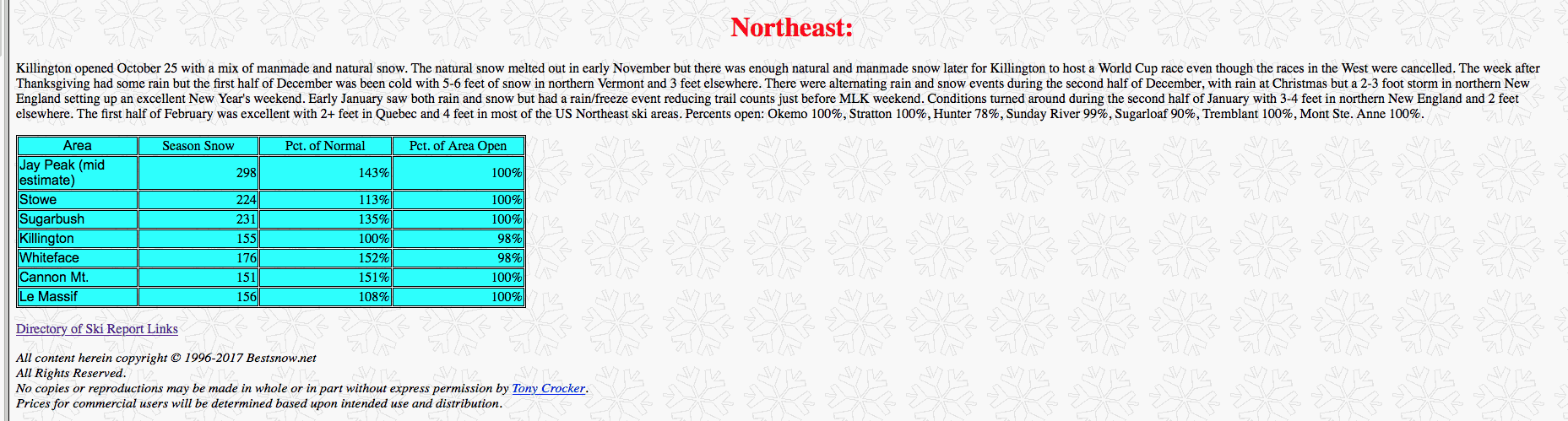
Northeast:
Killington was the first opening on November 8 as there was too much warm weather and rain in October. There was gradual terrain expansion on snowmaking since Thanksgiving but natural snow was mainly in northern Vermont. Second week of December snowfall averaged 3 feet in Northern Vermont and 2 feet elsewhere, setting up the region for a very good holiday season. The Northeast averaged 2 feet of snow during the second half of December, but there was bitter cold during most of the holiday period. In early January the cold has persisted with 1-2 feet of snow. Percents open: Okemo 98%, Stratton 92%, Sugarloaf 73%, Sunday River 77%, Hunter 81%, Tremblant 96%, Mt. Ste. Anne 93%.
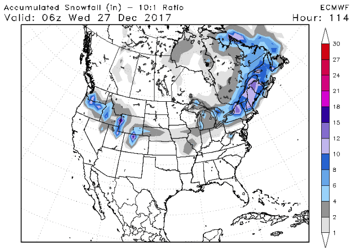
Winter is only a day old and Jack Frost is already planning a trip to America. Temperatures from Montana to Pennsylvania will range 20 to 25 degrees F below normal for this time of year. Three snowstorms will track across the country over the next week. The first storm starts tonight for northern New England, sparing most of the big cities. Around 6″-12″ is expected in Burlington, VT. The second will begin on tomorrow, with “1-5” Washington to Nebraska. This storm will continue through the middle of the country on Christmas eve, ending in New England on Christmas day. New York City will be right on the rain/snow line. A white Christmas for many will be in stark contrast to last 3 years where temperatures averaged 5-10 degrees above normal. Check out the expected snow total by next Wednesday: (European 12z model, Source: stormvistamodels.com)
The third storm has the potential to a pack a wallop. Models have been occasionally giving some areas major accumulations. However, they have not been consistent on who gets the bullseye. This is not uncommon for storm forecasts still more than a week away. The latest Euro certainly got a few people excited today with 12″ for much of the East Coast (DC, Baltimore, & NYC).
Those traveling in these in the East Dec 30th- Jan 1st should to pay attention to updates on this storm potential from their local TV mets and the National Weather Service.
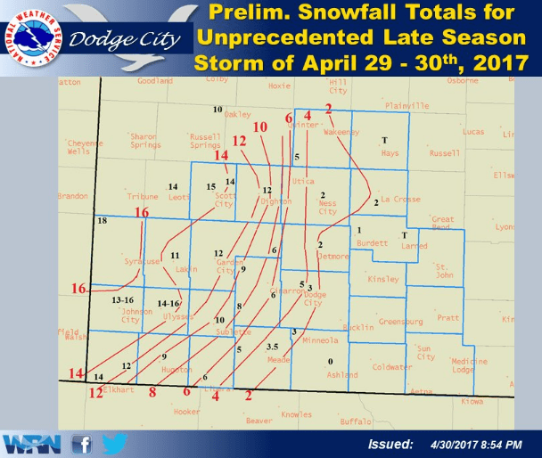
A deluge of weather issues plagued Kansas wheat areas over the weekend. Consequently, a three pronged threat (that Jim gave a heads up to his clients on) may lead to a decrease in crop quality. The major short position in the market means a lot of investors are taking a hit with today’s rally.
Snowfall
For the western half of Kansas, up to a foot of snow fell. Due to warmer temperatures, it was heavy wet snow that fell, rather than fluffy powder. This is important because wind and snow can knock heads off the plant, limiting its yield.
SOURCE:NOAA
Late Spring Shiver for Wheat
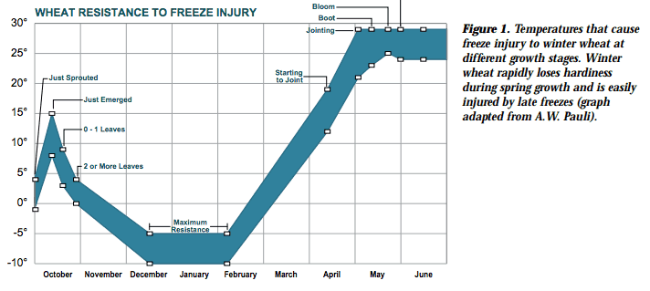
Wheat can survive freezing temperatures during the winter, while the crop is dormant. However, the crop came out of dormancy early this year because of the warm temperatures in March and April. In Kansas, 25% of the crop currently headed. This portion is most vulnerable to freeze damage, with injury typically occurring at 30F. Less developed wheat is more resilient to cold conditions, with damage occurring at 15F-25F. Check out this informative graphic from Kansas State University regarding temperatures and potential injury.
SOURCE: Kansas State University
Flooding
For those that were spared snow and cold, their consolation prize was abnormally heavy rainfall. Rainfall totals ranged 1″ to +4″ in eastern Kansas and Missouri. Flooded soils can deplete the developing plant of oxygen. However, wheat usually can survive one or two days of flooding. Severe storms, included several tornados, tore through the midwest and South. See the video below:
SOURCE:AP
Jim’s comment and market view of this unique weather impact on futures prices is only provided to subscribers and private clients.
A look at Ski Conditions in the U.S.and Canada So Far This Winter. Big Snows out West, Tell-Tale Signs of El Nino again.
Please go to our favorite ski site for more detailed reports of snow conditions. WWW.BESTSNOW.NET.
After a late start, snowfall has been abundant across the western U.S. skiing areas the past few months. Snowbird Mountain Resort’s YTD total so far is a whopping 358″. Over the past 30 years, their average total snowfall by the end of February has been 284″. Hence, a 70″ surplus is guaranteed by the end of February 2017. However, this is likely underestimated, as several more feet of powder are the forecast for this week. On the other side of the country, recent storms have helped turned the tide in the battle for a recovery season after the snow drought of 2015/16. New powder arrived just in time for skiing glades, snowshoeing and snowmobiling around Valentine’s Day. Consequently, many couples staying at bed & breakfasts and mountain lodges in Vermont enjoyed the fresh snow.
The drought is over in California with some historical rains and snows both beneficial and a detriment out west. Feet more snow is coming to the West through the beginning of March. The big time snows in northern New England will turn a bit icy with freeze-thawing the next 10-14 days as ski resorts in Vermont to New York and New Hampshire see day time highs climb well into the 40’s and 50’s at times. This will mean freeze-thawing and a lot of the power gone shortly. However, most studies and the chart we show below suggest a potential improving weather pattern for Northeast ski resorts and colder weather after about March 7th. The odds seem to favor a colder than normal March after that time which could mean good news for New England ski resorts.
As a result, you might be thinking “Ok Matt I get it, conditions are perfect. I’ve heard it all about it from my co-workers and family members. Enough is enough! Therefore, I’m booking my trip for the spring. Should I venture to the Northeast or risk the ‘Oregon Trail’ and head to the powder of the West? Where will I get more snow for my buck?”
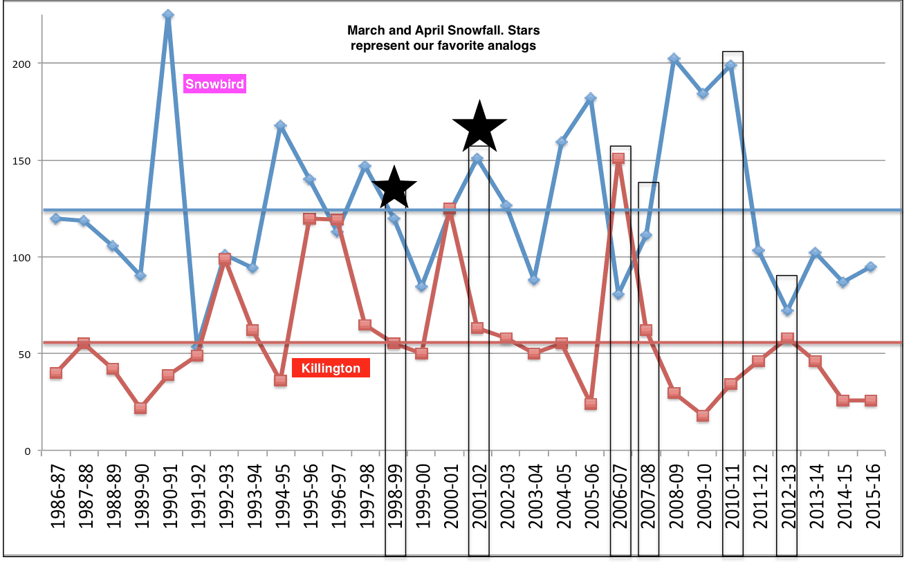
Analog Snowfall Forecast
To answer this, we took a gander at the historical late season snows for two mountains: Snowbird, Utah and Killington, VT. The late-season snowfall totals for the past 30 years (March-April) are shown in the image below. In addition, the average for Killington (Snowbird) is the flat red (blue) line. The years with black boxes highlight some of the analogs we’ve used to forecast the 16-17′ U.S. winter. These years are a mix of our sea ice analogs, +AMO, +NINO12, and +QBO. These are teleconnections. which help us forecast long range weather.
The chart above shows our favorite analog years and projected March-April snowfall. 1999, 2002, 2007, 2008, 2011, 2013 appear like the best analogs. However, when looking, for example at which of these years had incredible California snows and places like Snowbird already having more than 330″ of snow by early February, the spring of 2002 appears the best. You can see from the chart above that Snowbird had close to 150 inches of snow in March and Killington about 55 inches. While not written in stone (timing could always be a week or two off), this does suggest incredible snows still in Utah the next month or so. After freeze-thawing in New England the next 12-15 days, conditions could improve the last half to two-thirds of March for many New England ski resorts
March Temp forecast (below). After a record warm February for much of the U.S., somewhat colder weather can be expected later.
Comparing two of our favorite analogs—-notice the colder than normal outlook in March (top map) and above normal moisture over New England. This is at the surface, not 5,000-10,000 feet up. Hence, for example, the higher elevations such as Snowbird should get great snows into March, even though this map shows below normal snowfall in green. The blue represents above normal precipitin and possibly in the form of good snows in New England, following freeze thawing the next 2 weeks.
WEATHER WEALTH SAMPLE CONTENT
HELPING YOU MAKE THE BEST INVESTMENT DECISIONS BASED ON THE WEATHER
We use cookies to ensure that we give you the best experience on our website. If you continue to use this site we will assume that you are happy with it.