by Jim Roemer | Dec 22, 2017 | Forecast, Skiing
First White Christmas in Years
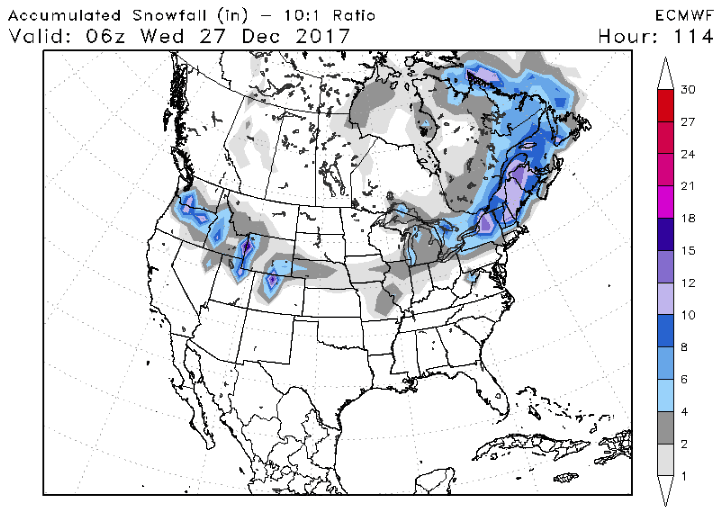
Winter is only a day old and Jack Frost is already planning a trip to America. Temperatures from Montana to Pennsylvania will range 20 to 25 degrees F below normal for this time of year. Three snowstorms will track across the country over the next week. The first storm starts tonight for northern New England, sparing most of the big cities. Around 6″-12″ is expected in Burlington, VT. The second will begin on tomorrow, with “1-5” Washington to Nebraska. This storm will continue through the middle of the country on Christmas eve, ending in New England on Christmas day. New York City will be right on the rain/snow line. A white Christmas for many will be in stark contrast to last 3 years where temperatures averaged 5-10 degrees above normal. Check out the expected snow total by next Wednesday: (European 12z model, Source: stormvistamodels.com)
The third storm has the potential to a pack a wallop. Models have been occasionally giving some areas major accumulations. However, they have not been consistent on who gets the bullseye. This is not uncommon for storm forecasts still more than a week away. The latest Euro certainly got a few people excited today with 12″ for much of the East Coast (DC, Baltimore, & NYC).

Those traveling in these in the East Dec 30th- Jan 1st should to pay attention to updates on this storm potential from their local TV mets and the National Weather Service.

Happy Holidays and Safe Travels!
-Best Weather Team
by Jim Roemer | Dec 12, 2017 | Commodities, Forecast
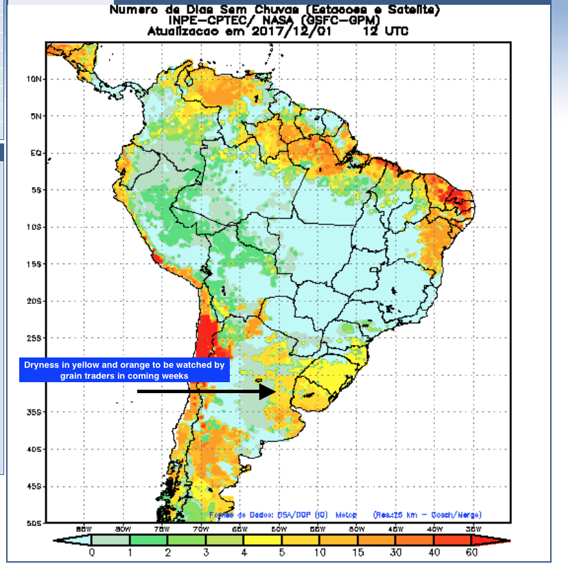
In the face of growing drought in the Plains and the historical brush fires out west, (which are causing sell-offs in certain insurance stocks and municipal bonds in parts of California are taking a hit) why has the wheat market not responded yet? The reason is due to the huge global supplies still hitting the market and the lower export prices in Russia, etc. due to record crops this past summer. Commercial grain companies and traders will “not panic” until we get into the March-May time frame and see whether the drought will expand. We are working on several studies with regards to this, but it is very early and most wheat weather markets do not begin till spring.
Global wheat stocks are significant, with the stocks to usage ratio at about 40%. Normally this means cash wheat prices below $4!! However, the developing drought will “ probably” keep us above $4 in KC July wheat this winter.
La Nina and WHWP
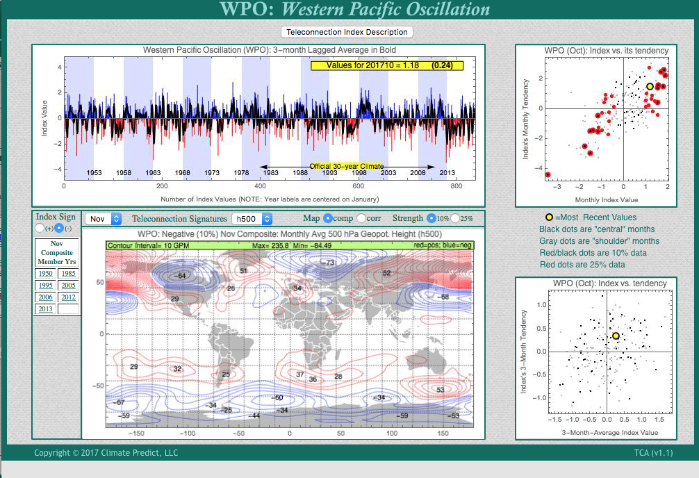
In the meantime, while most La Nina years would suggest dry weather in Argentina, soybean prices have taken it on the chin again due to a variety of factors. One of them has to do with the dryness in Argentina and southern Brazil being short-lived because of what we call the Western Hemispheric Warm Pool Index. A positive WHWP signal is almost unheard of during a La Nina. As Climatech shows towards the bottom of the page, late last week we issued a “caution flag” potentially increasing our more medium term outlook for Argentina grains to potentially wetter again.
A positive WHWP (box above) signal is almost unheard of during a La Nina . This is one of the few teleconnections that suggest wetter weather for Argentina again.


by Jim Roemer | Dec 5, 2017 | Commodities, Forecast
South America Grains
Grain traders are watching a developing La Niña. What happens to production over the next two to three months will have a big impact on corn (ETF:CORN) and especially South American soybean production (ETF:SOY) . In the event of another U.S. bumper crop, such as we saw in the summer of 2017, and lagging global exports, it will take a significant weather issue in South America to get grains out of the doldrums. This is sometimes possible with certain La Niñas.
Subscribers who have purchased our newsletter service on Seeking Alpha will be getting a few tips pursuant to our feelings about weather’s bullishness (or bearishness) for grains in the weeks and months ahead. Will wheat prices (ETF:WEAT) come out of its long term bear market? When spring arrives, dryness in the Plains will have more of an impact as the crop comes out of dormancy. The global glut in wheat continues to haunt the market. But this could be a whole new ball game in late winter or early spring, especially if we see other weather issues develop in Europe or Russia.
Argentina and Brazil
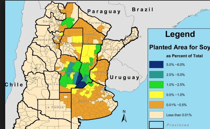
Argentina is expected to increase its soybean acreage this year. Changes to soybean export paces could help Argentine farmers. According to Commodity Basis, the major soybean growing states are Buenos Aires, Cordoba, and Santa Fe. The country accounts for 18% of the world’s soybean production. Although the nation exports only 7% of global raw soybeans, it’s the largest exporter of soybean oil and meal. In 2013, soybean meal was Argentina’s single largest export commodity, bringing in revenues totaling $10.7 billion, according to MIT data.
Brazil is the world’s #2 producer of soybeans, accounting for 30% of global production. The country has over 29 million hectares of land available for farming this crop. Brazilian grown beans have a higher protein content than those grown elsewhere, thereby fetching higher prices in international markets. In addition, they produce a significant quantity of non-genetically modified (non-GMO) soybeans which sell at a premium to the GMO variation. (Source: atlas.com)
Dryness for Plains wheat is typical of La Niña. However, it will take weather issues next spring in other parts of the world boost wheat prices:
by Jim Roemer | Nov 20, 2017 | Forecast
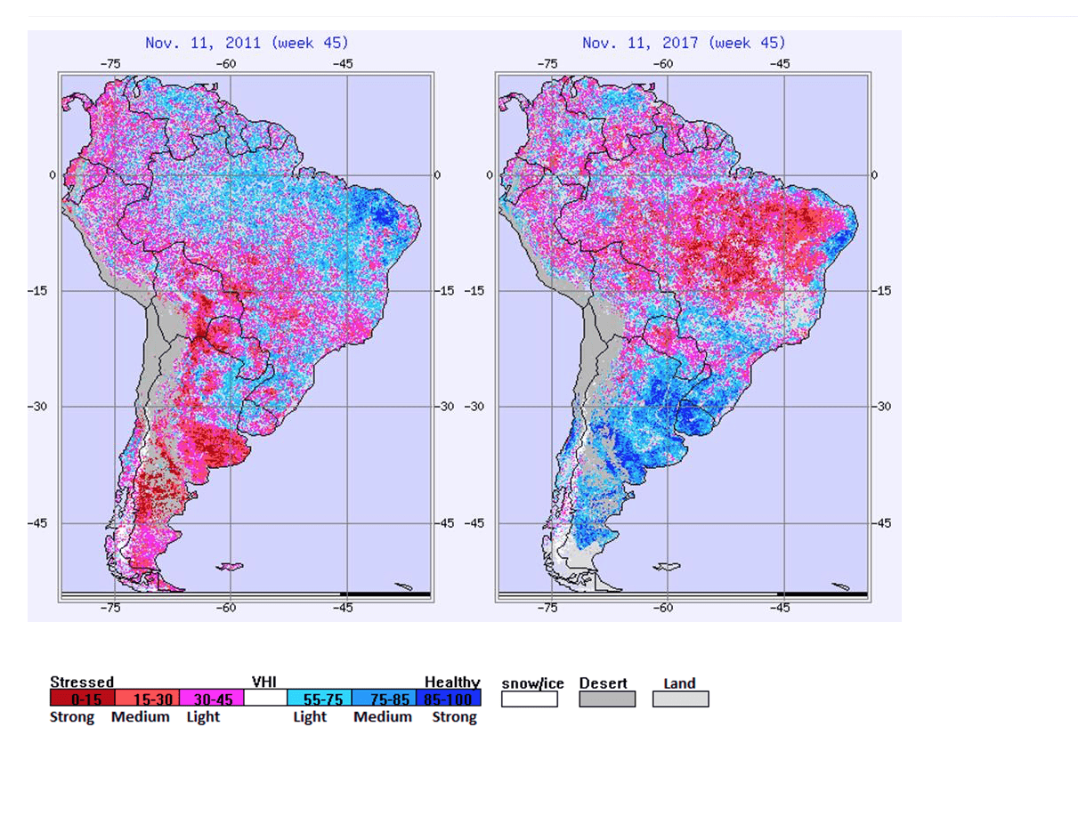
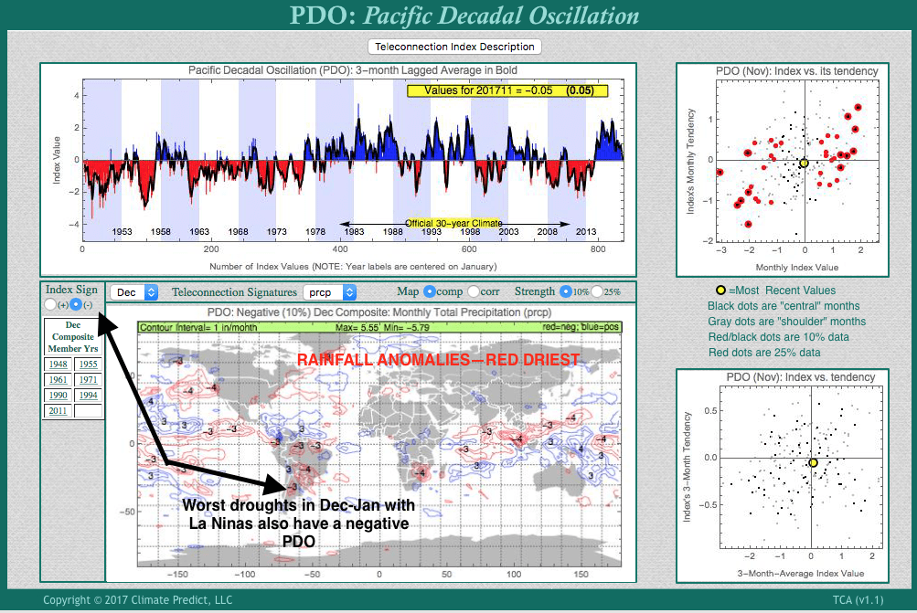
There has been some talk that the present La Nina is the strongest since 2011-2012; when droughts plagued, not only southern Brazil and Argentina soybeans, but U.S. crops the following summer. This resulted in a bullish long term cycle in grains. The present weak La Nina can be compared to one that resulted in major crop problems for grain. Climatech below, shows it is not as strong as that year. Additionally, the key for global grain weather is not only La Nina but what the PDO does over the next 6-9 months. Notice how much cooler it was during the 2011-2012 in the N. Pacific –> -PDO.

PDO in 2011
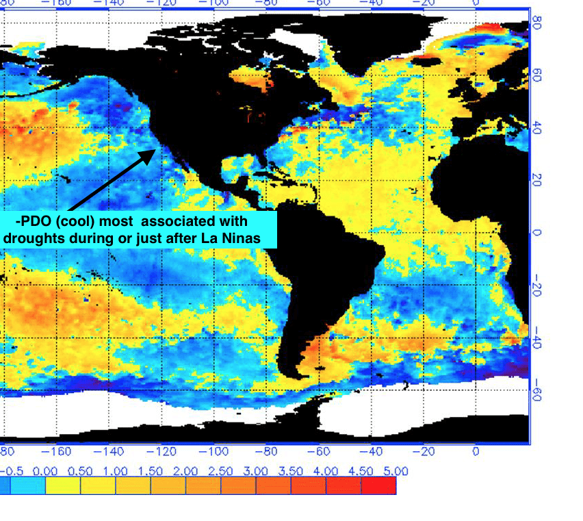
PDO in 2017 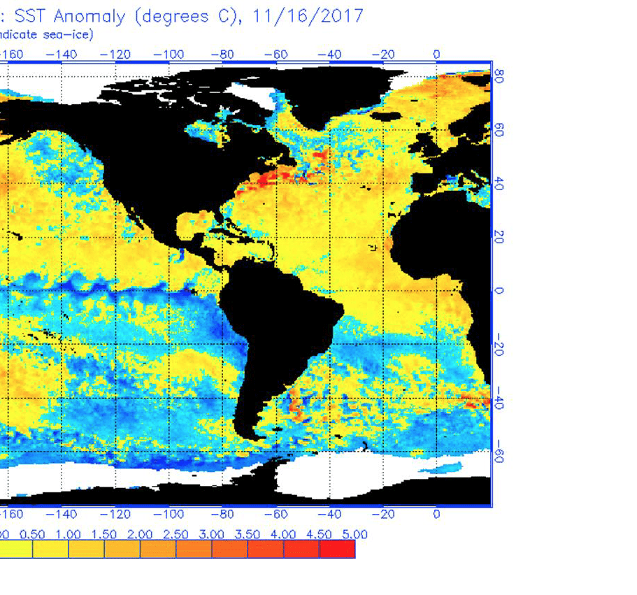
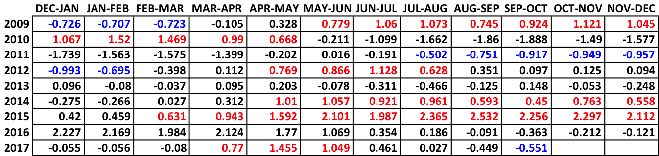
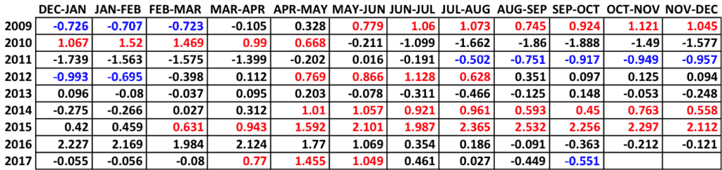
The MEI index measures both atmospheric and oceanic conditions. Positive (negative) values indicate El Nino (La Nina) conditions are present. The stronger the value, the greater the El Nino/La Nina. As you can see in the values below, we the 2011-12 was much stronger in November than current values. [Red El Nino, Blue La Nina]
La Nina and the Grain Market
Soil moisture levels were much drier in Argentina during other La Nina events than they are now. The sudden rally in soybeans, may be due to seasonal demand factors, that we pointed out often happen later in Nov-Dec, not just the talk of La Nina. Cool weather is likely in Argentina with off and on bouts of dry weather. Right now, from a study we did a week or so ago, we expect above normal soybean production in Brazil and normal to slightly below trend-line yields in Argentina the next few months.

My greatest concerns, as far as grains are concerned and La Nina, is for harvest and maturity delay issues for Australia wheat, a lower Argentina wheat crop and the potential for weather related issues of Plains wheat this winter and potentially next spring. But we have to see if the PDO goes negative come next spring to get a roaring bull market.
The world is awash in wheat and other non weather factors with regards to Egyptian tenders, China lowering their export price a while back and the huge Russian crop hitting the market have all been negative factors.
Other markets affected:
- Typically, La Nina’s favor improving global coffee production, the one exception is sometimes in Columbia where too wet conditions could lower crops, but that is still potentially at least 3-4 months away. Brazil is improving.
- La Nina also favors normal to above normal trend-line yields for west African cocoa and a low chance for a severe Harmattan—forget about any major bull market based on weather.
- Heavy rains can sometimes affect coal production and mining operations in Australia and lower Palm oil production in Malaysia.
For more information on natural gas and how to trade these markets, email at subscriptionsbestweather@gmail.com
by Jim Roemer | Nov 7, 2017 | Climatech, Forecast
As La Nina forms, and the oceans cool in the equatorial Pacific, winters tend to start out mild for the most eastern ski resorts and the majority of U.S. energy areas, but there are exceptions. 1995 and 1985 were two La Nina events that had a huge block over the NW part of Alaska to the arctic circle. The strong block, or negative Western Pacific Oscillation Index is just one feature that can result in cold weather and will influence natural gas and perhaps heating oil trading in the weeks and months ahead.
The colder outlook has helped natural gas prices soar through resistance, but any short to longer term weather forecasts is only reserved to paying clients. subscriptionsbestweather@gmail.com
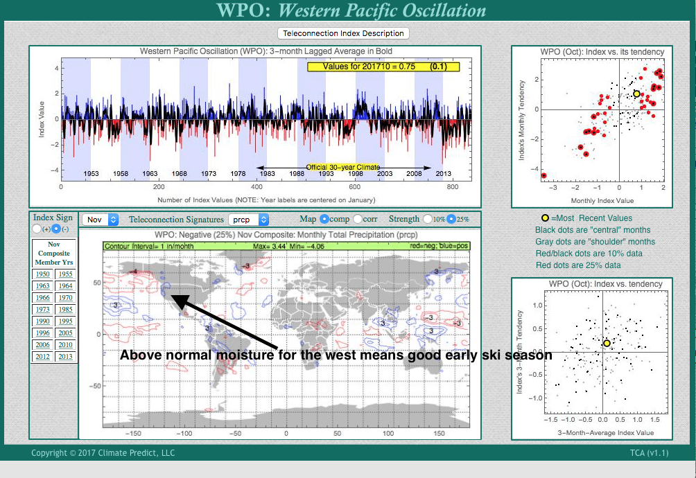
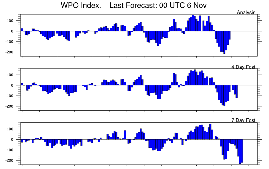
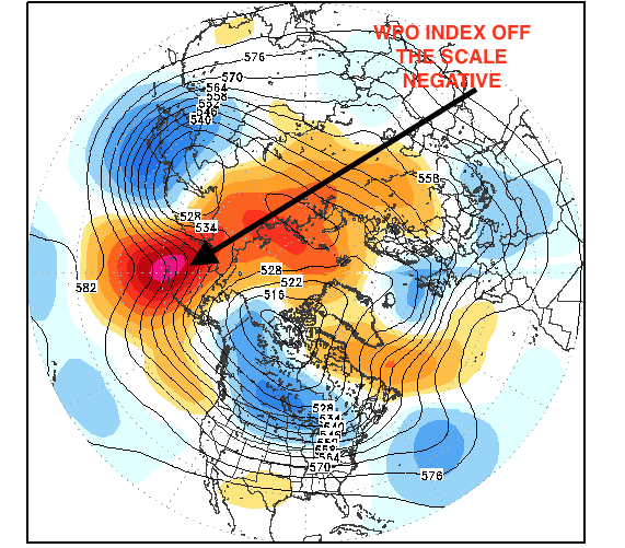
Another important factor to the northern Hemispheric winter is the NAO. Many of you have heard about this index. When there is a warm block over Greenland and the NAO is negative, severe cold and snows can invade the Northeast U.S. and/or Europe. Below we show our proprietary in house software Climatech http://climatepredictanalytics.com and how the WPO index in November can actually forecast a negative NAO. This increases the odds of a cold early start to the winter with lots of fireworks in the energy markets. But how to trade these kind of markets and any changes in the WPO/NAO relationship is only reserved, again, for paying clients.
MAP ABOVE WWW.STORMVISTA.COM
CLIMATECH’S NEGATIVE WPO INDEX——NOTICE THE WARM (RED BLOCK) OVER GREENLAND AND POTENTIAL NEGATIVE NAO
by Jim Roemer | Oct 31, 2017 | Forecast, Skiing
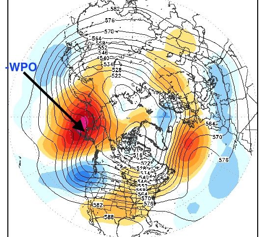
The negative Western Pacific Oscillation index (WPO) is depicted by a warm, strong block to the NW of Alaska well into November. The strong negative phase of the QBO (stratospheric winds, some 25-50 miles in the stratosphere) could result in this block remaining well into November. Its implications will be important for energy and natural gas traders, but only paid clients will get a heads up with respect to these markets. A week ago we began discussing a possible warm start to winter and natural gas prices have taken it on the chin as U.S. production is increasing, but will this continue? Subscriptonsbestweather@gmail.com
CREDIT: stormvista.com
Early Snow for Ski Areas
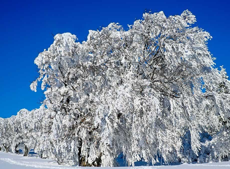
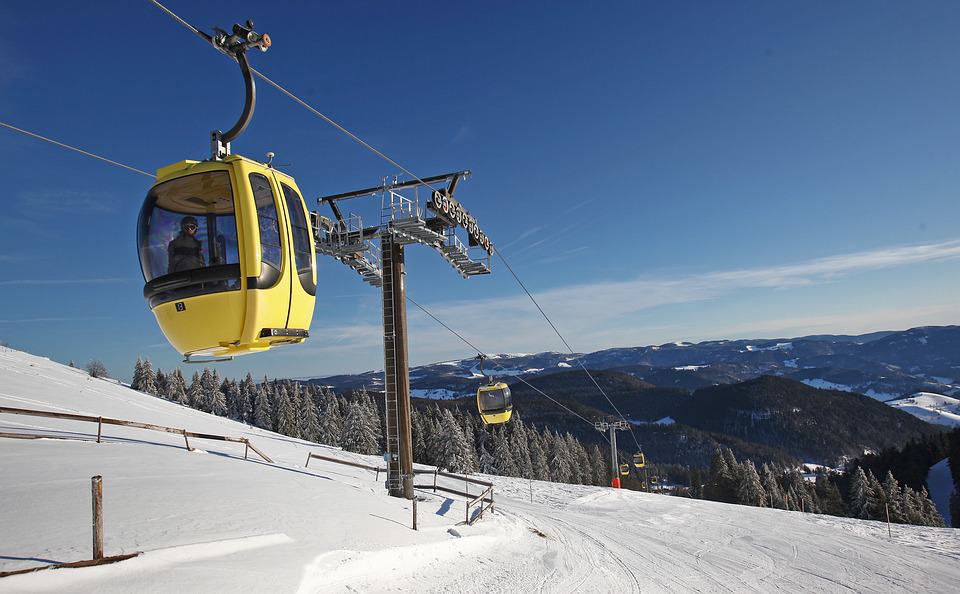
I have been doing ski forecasting for Snowbird, Utah for over 15 years and used to forecast for more than 25 ski areas nationwide, particularly in Vermont and New Hampshire. The combination of a -WPO coupled with a developing La Nina suggest a very snowy November with feet of snow from the Cascades to the Sierras and Utah. The map below shows the relationship of moisture in November in years when we have this strong block (-WPO) as shown above—very snowy with feet of snow. Usually it is El Nino not La Nina that results in the best ski seasons out west, but there are exceptions. For more information please visit www.bestsnow.net