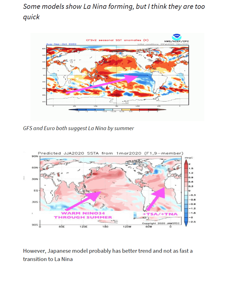
Many forecast firms and models suggest La Niña type conditions this summer or fall that would of course have global impacts on many commodities. However, I believe that forecast models have been wrong and too bold predicting cooling ocean temperatures and a La Niña.
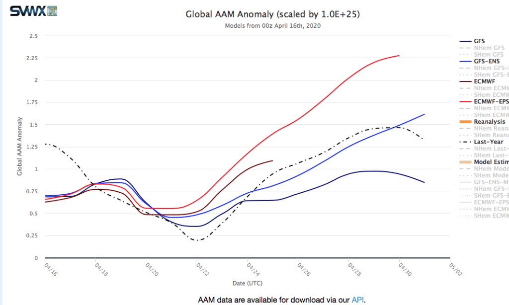
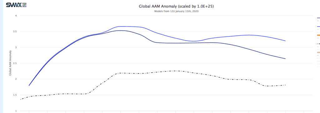
Presently, we are seeing what we call +positive Global Angular Momentum (+GLAAM) occur. This teleconnection, combined with the oceans being slow to cool along the equator portend potential off and on weak El Niño conditions (not La Niña) into at least late spring.
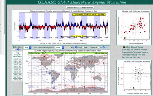
Global atmospheric angular momentum (GLAAM) is a measure of how fast the atmosphere is spinning relative to the earth’s rotation. During the negative phase of GLAAM the atmosphere moves more slowly relative to the earth’s rotation. This causes mid-latitude jet streams to produce higher amplitude ridge and trough patterns. Negative GLAAM is common when La Niña is present. However, the opposite is happening now (see above). Positive (GLAAM). Hence, we still have (in my view) occasional weak El Niño conditions.
What implications will this have for farmers’ crops around the world in coming weeks and months? How might you take advantage of this information to trade everything from grains to soft commodities?
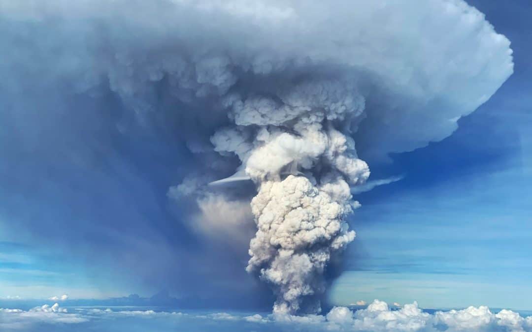
The report below discusses various global weather occurrences and factors that make me feel that El Nino conditions exist, globally. This is in contrast to most computer models and weather forecast firms. The Taal volcano could possibly alter some computer model forecasts.
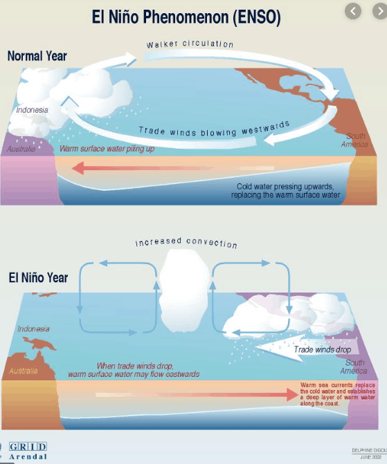
El Nino
Global weather acting like an El Nino
Grain Weather—
After a stellar rally in soybeans the last month on ideas of a truce with China and the potential for more major soybean purchases in the months ahead, generally ideal South American weather has (at least for now), topped out the soybean market. Typically, during El Nino type events, Argentina corn and soybean crops are spared any major weather problems. In fact, usually yields are above normal for grain crops
While wheat prices continue to act technically strong, influenced from a variety of factors–1) The highest soft-red wheat stocks in several years; B) Lower US planted acreage; C) The chances of a major reduction in wheat plantings this spring (Australian fall) due to the historical dry soils and fires, excellent rains have hit Argentina soybean areas. This too happens during certain El Nino events, though the record forest fires and deaths to millions of animals must be, at least partly, attributed to climate change.
Warm, stormy US Weather—
Severe weather continues to batter much of the US south, while record warm temperatures can be at least partly attributed to El Nino type conditions.
Tropical Commodity Growing Areas–
Drought easing rains in northern Brazil coffee areas and a warm, dry winter for Ghana in west Africa are also signs that perhaps El Nino has returned. The Indonesian drought is another example
In my view, standard computer models and almost all weather forecast firms are incorrect saying we have “El Nino” neutral conditions. The above mentioned global weather and crop conditions suggest this.
Here are more reasons, below that I believe El Nino is present.
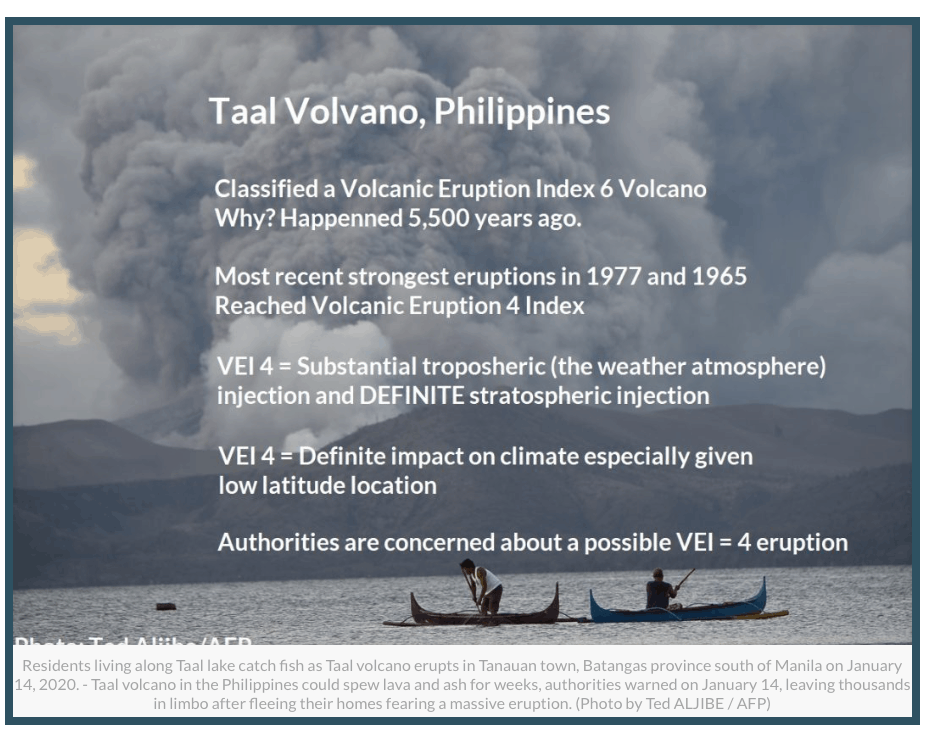
1–Taal Volcano needs to be watched.
If enough ash spills into the stratosphere, this would be labeled a VEI 4 volcano. A VEI 4 has only happened several times in the last 30 years and has been known to help cause an El Nino (Mt. Pinutuba), for example.
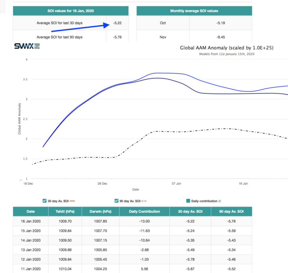
2–SOI index continues to trend negative; while GLAAM is positive
While everyone refers to ocean temperatures in the equatorial Pacific as being key to whether there is an El Nino or La Nina, just as important is the Southern Oscillation Index and whether there is positive or negative Global Angular Momentum (GLAAM).
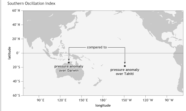
SOI INDEX
The oldest indicator of the ENSO state is the Southern Oscillation Index (SOI): the difference between the atmospheric pressure at sea level at Tahiti and at Darwin (1). A seesaw in pressure at these locations reflects the atmospheric component of ENSO, discovered in the early 1900s by Walker and Bliss (1932) and others. During El Niño, the pressure becomes below average in Tahiti and above average in Darwin, and the Southern Oscillation Index is negative. During La Niña, the pressure behaves oppositely, and the index becomes positive. Right now, pressures have been lower than normal over Australia, partly responsible for the severe drought and heat recently.
The SOI index has been trending mostly negative for weeks
3–GLAAM is trending positive
Another teleconnection that Jim Roemer has been using to forecast El Nino conditions is GLAAM. When it is positive, El Nino conditions can exist. However, this is only true when the SOI index is negative (as described above) and there are warm ocean temperatures in the Equatorial Pacific (we have all of these factors, now).
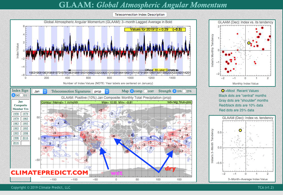
You can see how Jim Roemer’s long-range weather forecast program predicted (below) and easing in the northern Brazil dryness to coffee earlier in January and some heat and dryness coming to west African cocoa. This is associated with +GLAAM values and could well suggest that El Nino, not neutral conditions have been occurring in at least some parts of the world.
January analog years (left) and global rainfall trends with positive GLAAM
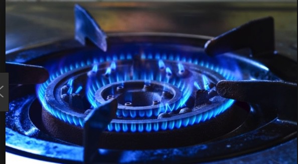
Natural gas production has consistently reached new record-high levels in recent months. The Energy Information Administration (EIA) expects production growth will begin to decelerate in the coming months, but it may take some sustained hot weather to keep natural gas prices out of the doldrums. Two weeks ago, I was on Bloomberg TV, during hurricane Barry. The interviewer raised the question of production disruption causing a price spike. I explained that any price impact would be negligible due to the fact that the lion’s share of natural gas production is on land (shale) not in the Gulf anymore.
While lower natural gas prices sometimes cause production to tail off, improved drilling efficiency, year-over-year cost reductions, and higher associated gas production from oil-directed rigs all mean that we need sustained hot weather in major producing areas this summer or several major Gulf coast storms to create any more than a brief short covering rally in natural gas prices, in my opinion.
The weakening El Niño coupled with Global Angular Momentum (GLAAM) will impact global weather patterns in the weeks to come, thus affecting certain markets, particularly natural gas, corn, and soybeans.
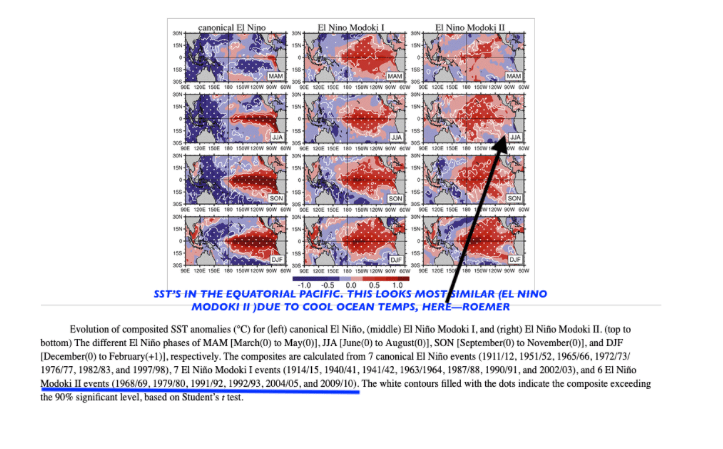
El Niño is weakening but we still have a Modoki II event. What’s that?
There are 3 different types of El Niño events as I show above. The cases to the far right are the most similar, in which ocean temperatures across the equatorial Pacific are warm along and west of the dateline and cool off the coast of Peru. This is fairly unusual and has only occurred in roughly 25% of all El Niño cases (1968-69; 1979-80; 1991-92; 1992-93; 2004-2005;2009-2010)
El Niño events typically lead to a cool summer across major natural gas producing areas. However, when El Niño weakens (as it is now), sometimes the above-mentioned GLAAM can become negative and result in a surge of summer heat that can affect late summer corn and soybean crops and help natural gas prices rally.
My map above shows how the United States late summer can be hotter than normal (red) when GLAAM is negative. GLAAM is a complex variable related to the earth’s spin and frictional torque. Without going into too much detail, when GLAAM is negative, we are thought to usually be in a La Niña State; positive, an El Niño State. Negative GLAAM resulted in the back to back Midwest corn and soybean droughts back in 2011-2012 and partially responsible for the “Arab Spring” and soaring grain prices in several countries that set up more warfare in the Middle East, due to famine. While not all negative GLAAM summers result in heat waves, droughts and famine, this teleconnection can still be used as guide to forecast summer weather.
BOTTOM LINE:Presently, we are in a weak EL Niño Modoki II event with a negative GLAAM that suggests EL Niño is weakening. However, due to low solar activity the effects of this El Niño Modoki II event could actually persist into the late summer and fall. There are very few cases to look at to compare these climatological variables, but I have a pretty good hunch what to look for. Usually, however, for a major summer bull market in grains and natural gas to occur from La Niña, not El Niño Modoki, needs to be present. But there are exceptions! Are we in one of those cases?
Will India’s drought get worse and finally cause sugar prices to rally? Can natural gas prices and corn and soybeans have late summer heat? If you are interested to know more and my views, please email me at subscriptionsbestweather@gmail.com
WEATHER WEALTH SAMPLE CONTENT
HELPING YOU MAKE THE BEST INVESTMENT DECISIONS BASED ON THE WEATHER
We use cookies to ensure that we give you the best experience on our website. If you continue to use this site we will assume that you are happy with it.