
El Niño’s Plot Twist: Forget the Drought—Now It’s the Water
El Niños plot twist: Forget the drought – Now it’s the water: From a hurricane near Hawaii and a major East Coast Nor’easter to soaking rains in the Plains and Brazil, excessive moisture is becoming the new weather story for commodity markets. It will even turn a bit too wet for the corn and soybean harvest in much of Iowa, parts of Illinois, Nebraska, Minnesota and Missouri next week.
By Jim Roemer — Meteorologist/Commodity Trading Advisor
Climatelligence & WeatherWealth
For months, traders have associated the developing powerful El Niño with the usual buzzwords: drought, heat and crop stress.
But Mother Nature apparently misplaced the script.
As we head into the final weekend of September, some of the most important weather stories around the world aren’t about drought at all.
They’re about too much water.
And that distinction could become increasingly important for everything from coffee and sugar to wheat and cotton, while millions of Americans deal with an unusually stormy pattern.
🌊 From Hawaii to New England: El Niño Flexes Its Muscles
Consider the extraordinary contrast between the Pacific and Atlantic hurricane seasons.
While the Atlantic has yet to produce a hurricane this season—an exceptionally unusual situation this late in September—the eastern and central Pacific have already produced nine hurricanes, including five major hurricanes.
Now Hurricane Nolo is south of Hawaii.
As of Thursday evening, Nolo had strengthened to a hurricane with sustained winds near 75 mph, about 255 miles south of South Point on the Big Island. I have warned of the potential for life-threatening to catastrophic flash flooding on the Big Island into the weekend.
That is classic El Niño geography: Pacific tropical activity becomes much more important while Atlantic activity can be suppressed by stronger upper-level winds.
But thousands of miles away, another storm is stealing the headlines.
🌧️ A September Nor’easter for Millions of East Coast Residents
A powerful, slow-moving coastal storm is developing along the East Coast.
I predict the Nor’easter to linger near the northern Mid-Atlantic and Northeast coast through the weekend and into early next week, producing heavy rain, strong winds, coastal flooding, beach erosion and dangerous surf.
Check out this weather map for early Sunday a.m.
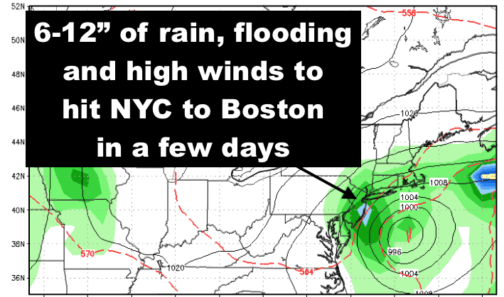
Source:Stormvistamodels and WeatherWealth newsletterThis isn’t necessarily a quick Saturday rainstorm.
It may sit and spin.
From New Jersey and Long Island into Connecticut, Rhode Island and Massachusetts, millions of residents could experience a prolonged period of miserable weather.
Some forecasts suggest 2–4 inches of rain from portions of New Jersey northward, with localized totals of 4–6 inches around Long Island and the Boston area, while coastal New England could experience wind gusts over 50 mph.
The bigger problems may ultimately be flooding, power outages, coastal erosion and transportation headaches rather than simply the rainfall totals.
So while much of the Atlantic hurricane season has been remarkably quiet, the atmosphere has found another way to create havoc.
El Niño doesn’t mean “no storms.” It often means the storm tracks get rearranged.
🌾 Plains Wheat: Finally, the Rain Farmers Have Been Waiting For
Now let’s move from weather inconvenience to commodity opportunity.
One of the most dramatic changes is occurring across the Texas Panhandle, Oklahoma Panhandle and western Kansas.
These areas desperately needed moisture heading into winter wheat planting.
Kansas State University reported recently that 91% of Kansas was abnormally dry or worse, leaving many producers wondering whether they would have to “dust in” wheat seed and wait for rain.
Suddenly, the pattern has flipped.
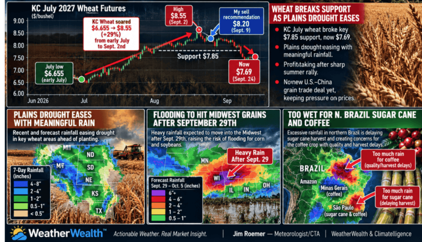
Parts of western Kansas and the Texas/Oklahoma Panhandles have already received several inches of rain, and additional wet weather is possible. The Weather Prediction Center reported areas receiving another 1.5–2.5 inchesafter earlier 2–3″+ totals, noting that most of the precipitation would be beneficial despite localized flash-flood concerns.
In some locations, rainfall during this wet cycle may amount to roughly 200–400% of normal.
For winter wheat, this is potentially excellent news. Trading wheat on my prediction two weeks ago was one of my highest confidence recommendations in the “paid subscription section of my newsletter below.”
This one trade alone already paid for 7 years to a subscription to Climatelligence since early September’s wheat trade recommendation, alone.
Instead of planting wheat into powder-dry soil, farmers may suddenly have something they haven’t enjoyed consistently in years:
A legitimate moisture profile for germination and establishment.
That could improve emergence and early root development and reduce one of the important weather premiums that helped support Kansas City wheat prices earlier this summer.
👕 Cotton: The Same Rain Can Be Bad News
Here is where commodity weather becomes fascinating.
The exact same rain that helps wheat can hurt cotton.
West Texas cotton has spent much of the growing season battling drought. Earlier rainfall would have been welcomed.
But late September is different.
Cotton is approaching maturity and harvest. Persistent heavy rain can interfere with boll opening and defoliation, slow harvest, reduce fiber quality and—if accompanied by wind—knock open cotton from plants.
So the commodity-weather equation has suddenly become:
WHEAT: 🌧️ Rain = mostly beneficial
COTTON: 🌧️ Too much rain = potentially bearish for crop quality and harvest
One storm system. Two crops. Completely different consequences.
That is why simply saying “rain is bullish” or “rain is bearish” is one of the biggest mistakes commodity traders can make. Timing matters as much as rainfall totals.
☕ Brazil Sugar & Coffee: From Perfect Flowering Rain to Too Much of a Good Thing?
Brazil provides an even better example.
September rains initially looked like exactly what coffee producers wanted.
After the dry season, rainfall stimulates flowering for the 2027 coffee crop.
But the rains have become increasingly persistent in important areas of Minas
Gerais and São Paulo.
However, I am going against the crowd. I have warned that rain could interfere with the final stages of the old coffee harvest and drying operations.
More recently, producers reported that wet weather was delaying the collection of coffee still on the ground just as the new flowering cycle was beginning.
And now another concern is developing.
What happens if it keeps raining?
The Cerrado Mineiro harvest is roughly 99% complete, but recent rain and hail have increased concerns about diseases including phoma and bacterial infections in affected areas.
That does not mean Brazil suddenly has a coffee crop disaster. Far from it.
The early bloom may ultimately prove beneficial.
But persistent excessive moisture following flowering can raise disease pressure and complicate fruit setting. The next several weeks could therefore become far more important for coffee traders than the impressive early flowering photographs circulating around the market suggest.
The coffee story may be shifting from “great rains for flowering” toward “how much rain is too much?”
I advised farmers and traders to sell wheat. As of this writing early Friday a.m. the trade is ahead $2,000 a contract. Put protective stops in if you sold wheat in my advice in the last week or two to preserve $1,000 or more profits, so you do not lose
I also like the sugar ETF (CANE) and long March, 2027 $6000 cocoa calls.
I also have some new information about the coffee, grains and natural gas but that is in my WeatherWealth premium newseltter
Finally, rainfall could exceed 200-300% in parts of the Midwest corn and soybean belt (blue) for about a week delaying the harvest next week.
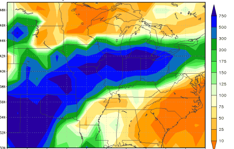
Source: Storm Vista