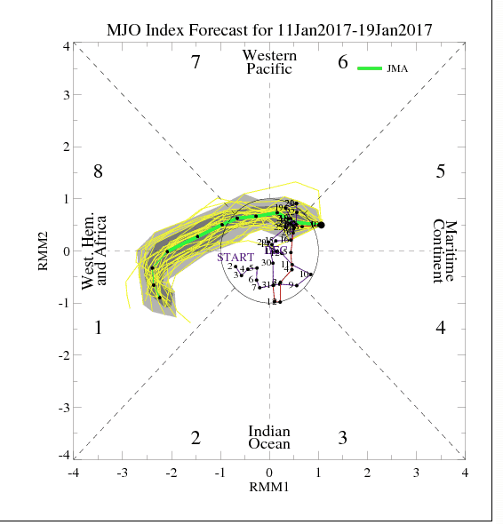
In one of the most complex, volatile U.S. weather patterns for natural gas prices in years, record warm weather and melting snows these next 10 days will be followed by yet some more changes. The Madden-Julian Oscillation (MJO) is the major fluctuation in tropical weather on weekly to monthly timescales. The MJO can be characterized as an eastward moving ‘pulse’ of cloud and rainfall near the equator that typically recurs every 30 to 60 days. It can sometimes change weather thousands of miles away around the globe.
We can see that it is forecasted to be in phase 1 in the next week or so that may result in a very stormy weather pattern coast to coast with potential snow events again in the Midwest and/or deep south or east, as we head later in January and February.
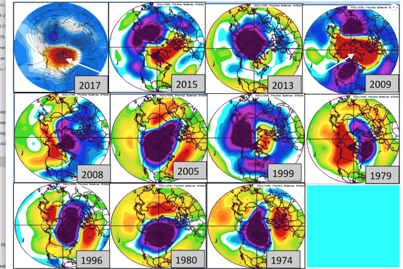
The second map towards the bottom of the page illustrates what may be the first stratospheric warming event in weeks south of the North Pole. If this occurs, it is possible by February the NAO/AO index may become more negative than originally thought.
- KEY POINT—The weather pattern has had a ton of volatility. Most of our studies suggest a cold March for the Midwest and East, but volatile weather the next 5 weeks. Odds are good that a cold end to winter will occur and that eastern ski resorts will be blessed later on. However, once again we have 2 features (MJO) and stratospheric warming that if they persist could portend colder weather for much of the Midwest, deep south or Northeast later in January and early February. This will result in more volatility in the natural gas market, following the recent sell off on warm weather.
Trading natural gas will continue to be a weather market, but daily advice in this market is only accessible to a hedge fund I advise in this and multiple ag commodities around the world.
STRATOSPHERIC WARMING LOOKS MORE EVIDENT LATER THIS MONTH–THIS MAY PORTEND A COLDER OUTLOOK AGAIN LATER. IF THIS BLOCK (RED) GETS ESTABLISHED FOR MORE THAN JUST A WEEK, IT COULD SUGGEST THE LATER PART OF THE WINTER WILL BE COLDER AND SNOWIER THAN NORMAL. 2009 WAS A COLD MID-LATE WINTER. OVERALL, IT HAS BEEN HARDER THAN NORMAL THIS WINTER TO GET A HANDLE ON WHICH INDIVIDUAL ANALOG WOULD BE A BETTER FIT. SOMETIMES LOOKING AT ONE YEAR, SUCH AS 2009 OR AN OTHER, CAN BE A DANGEROUS GAME IN FORECASTING.