
Climate Predict Lite
The Best Medium to Long-Range Weather Forecast Tool in the Industry
FREE ACCESS
Start using our Lite Version above for FREE ACCESS to receive 70 years of historical monthly global teleconnection snowfall, hurricane, and other weather data.

Our Design & Development Process
Our program will educate the weather enthusiast how TELECONNECTIONS, such as El Nino, sea ice, and ocean temperatures thousands of miles away influence global climate and can help you forecast the weather better.

HEDGE FUNDS/COMMODITY TRADERS

METEOROLOGISTS

SNOW AND HURRICANE ENTHUSIASTS

COLLEGE PROFESSORS
To View and Utilize Climate Predict Software, Please Login To Use On Desktop
Want Access To The PRO Version?
Climate Predict Pro includes 5 additional weather forecasting tools.
Fill out the interest form below for more information and access to Climate Predict PRO

Benefits + How To Use
A sophisticated, yet easy to use, analysis platform for commodity and weather risk forecasting…

Whether you are a commodity or weather derivatives trader, meteorology student, or atmospheric science professor, agribusiness, or work for major insurance, utility, retail company, or ski area, CLIMATE PREDICT is
the most advanced, graphical, and reliable medium-long range weather forecast available for you. CLIMATE PREDICTS’s web-based software platform is a weather risk and commodity price inference toolbox designed
to remove the burden of online processing of historical teleconnection index and weather data.
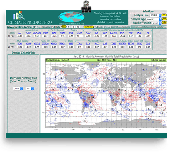
Updated twice a month, CLIMATE
PREDICT integrates more than 30 global teleconnections with various forecasting tools we developed. These tools combine a 70-year historical record of teleconnections and monthly weather anomalies with our own
research in drawing analog relationships for rainfall, temperature, and jet-stream patterns, up to 5 months in advance for any location in the world. A global warming algorithm adjustment is built into our program.
New features such as a unique hurricane forecasting tool, crop production, and historical yield and commodity price relationships will also be added.

This map shows snowfall anomalies for the very snowy Northeastern U.S. winter in 2014.
You will have access to the most updated historical database for snowfall and hurricane information back to 1949.
In addition, learn how to make “better weather forecasts”, up to 5 months in advance, using teleconnections such as El Nino, Sea Ice, and many more.
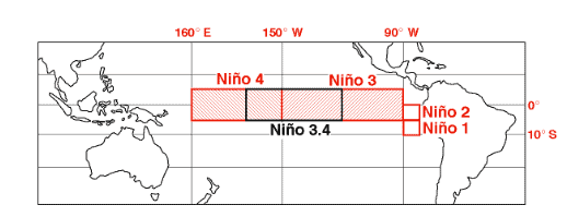
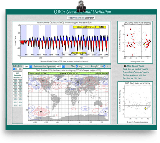
El Niño–Southern Oscillation (MEI, NINO 1+2, NINO 3, NINO 3.4, NINO 4)
Probably the most well-known of all teleconnections, La Niña and El Niño are irregularly periodic variations in winds and sea surface temperatures over the tropical eastern Pacific Ocean, affecting the climate of much of the tropics and subtropics. It disrupts global weather patterns thousands of miles away and has a huge influence on the hurricane season and produces weather disasters in some areas and benign weather in others.
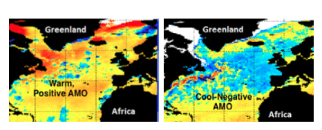
The Atlantic Multidecadal Oscillation (AMO)
is a climate cycle that affects the sea surface temperature (SST) of the North Atlantic Ocean. Warm vs cool cycles in the North Atlantic have a huge impact on hurricane storm tracks, global rainfall patterns, etc.
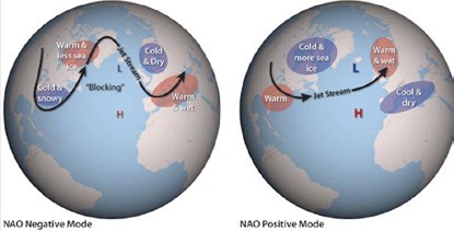
The North Atlantic Oscillation (NAO)
is a weather phenomenon in the North Atlantic Ocean of fluctuations in the difference of atmospheric pressure at sea level (SLP) between the Icelandic low and the Azores high. Through fluctuations
in the strength of the Icelandic low and the Azores high, it controls the strength and direction of westerly winds and location of storm tracks across the North Atlantic. It has a big impact on winter weather in the United States and Europe and when forecasted accurately is a key teleconnection in winter natural gas and energy trading.

The Indian Ocean Dipole (DMI), also known as the Indian Niño, is an irregular oscillation of sea-surface temperatures in which the western Indian Ocean becomes alternately warmer and then colder than the eastern part of the ocean. This index will give the CLIMATE PREDICT user big clues in forecasting droughts, floods, etc. for much of India and Southeast Asia.
It has been helpful for us to forecast major production cycles and price moves of such tropical commodities as sugar and cocoa.
Historical Maps
Download monthly weather maps for rainfall, temperature, snowfall, and hurricane tracks and 70 years of teleconnection data

Out Predict Computer Model 6-10 & 11-15 Day Forecasts
Plugin teleconnections such as El Nino, the NAO index, etc. and predict rainfall and temperature trends weeks in advance
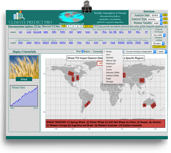
Commodity Forecast Tool
Predict weather months in advance for the global crop or energy region of your choice
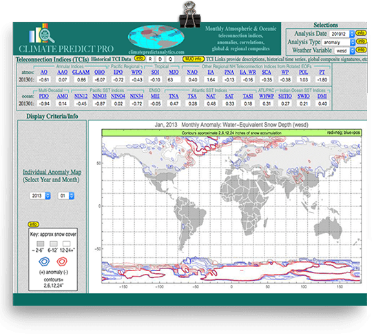
Predict Snowfall
Historical global, monthly snow cover maps and how teleconnections influence snowfall
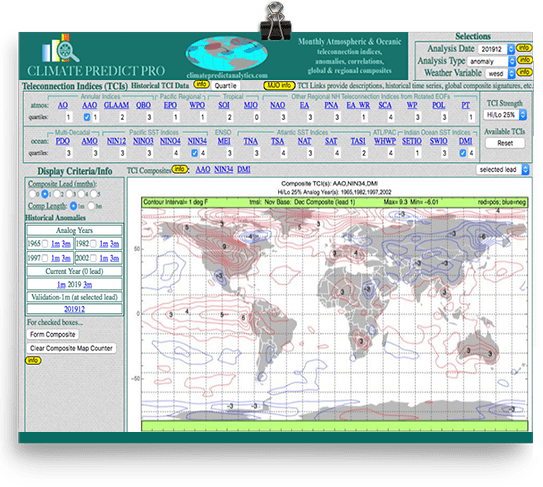
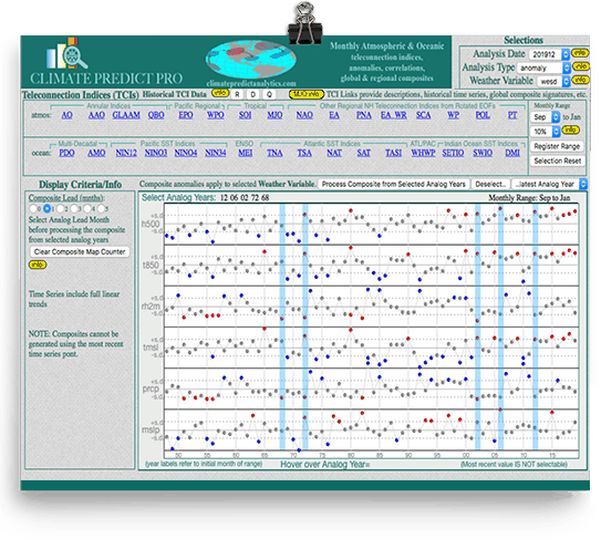
Teleconnection Analog Tool
Forecast any weather variable up to 5-8 months. Find the best analogs and the most important climatic correlations. (Shown above is how Climate Predict Pro predicted the warm 2019-2020 winter months in advance)
Jim Roemer’s “Weather Weirdo” Forecasting Tool
Compare weather extremes and records anywhere in the world and find similar analog years
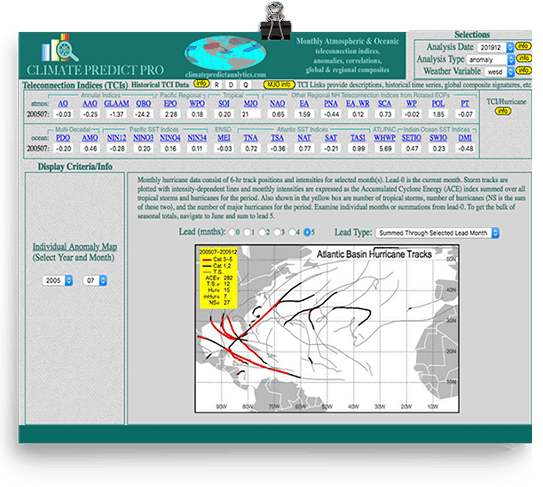
Hurricane Tracks
Largest historical database of hurricane tracks and ACE
Analog Years & Teleconnections
Learn how 28 different teleconnections can influence global weather, months in advance
Historical Maps
Download monthly weather maps for rainfall, temperature, snowfall, and hurricane tracks and 70 years of teleconnection data
Out Predict Computer Model 6-10 & 11-15 Day Forecasts
Plugin teleconnections such as El Nino, the NAO index, etc. and predict rainfall and temperature trends weeks in advance
Commodity Forecast Tool
Predict weather months in advance for the global crop or energy region of your choice
Predict Snowfall
Historical global, monthly snow cover maps and how teleconnections influence snowfall
Teleconnection Analog Tool
Forecast any weather variable up to 5-8 months. Find the best analogs and the most important climatic correlations. (Shown above is how Climate Predict Pro predicted the warm 2019-2020 winter months in advance)
Jim Roemer’s “Weather Weirdo” Forecasting Tool
Compare weather extremes and records anywhere in the world and find similar analog years
Hurricane Tracks
Largest historical database of hurricane tracks and ACE
Analog Years & Teleconnections
Learn how 28 different teleconnections can influence global weather, months in advance
Chief Advisors

James Roemer | Co-Founder - Climate Predict
Mr. Roemer is one the most recognized meteorologists in the world with over thirty years of experience as a commodity research analyst and weather forecaster for major grain companies, energy companies, and hedge funds. Mr. Roemer is a principal of Best Weather, Inc., a registered Commodity Trading Advisor (CTA) with the Commodity Futures Trading Commission (CFTC) and is an associate member of the National Futures Association (NFA) and has consulted with thousands of farmers, futures traders and currently advises large institutional investors. Mr. Roemer is one of a few meteorologists in the world who has an understanding of commodity trading, market analysis and long-range weather forecasting. Mr. Roemer has a strong understanding of technical analysis, cycles, and the psychology of commodity markets. He has advised thousands of skiers, sometimes weeks in advance, where they should hit the slopes.

Doug Stewart, Ph.D., Co-Founder; Designer of Climate Predict
Dr. Douglas Stewart, C.C.M. holds graduate degrees in meteorology from M.I.T. (S.M) and the University of Miami (Ph.D.). He has more than 35 years of experience developing computer models and analyzing geophysical data sets in support of meteorological and applied climate studies and has over 15 years of experience in developing web-based software. He has developed web tools to project commodity and equity prices and has developed sophisticated patent-pending software for his Weather Risk Mapping business. During the late 1990s, he and his colleagues at Climatological Consulting Corporation developed a Web tool for calculating the fair market value of HDD and CDD weather derivatives and conducted several workshops on pricing weather derivatives for the emerging weather risk market. Dr. Stewart has been published in the Journal of the Atmospheric Sciences, Monthly Weather Review, Journal of Applied Meteorology and Atmospheric Environment.

Martina Schmidt, Ph.D., Corporate Adviser/Strategist
Martina holds a Ph.D. in Finance with a focus on International Finance and an MBA with a focus on International Marketing, both from Florida Atlantic University. She provides investment research, strategic consulting, and marketing support services to Best Weather’s team. Martina has over 20 years of experience in the field of financial analysis and research, real estate investment and sales, as well as financial education. Besides having been involved in the marketing and financial analysis of multi-million dollar commercial and residential real estate projects, she has worked in financial management and sales for an aviation company and given multiple corporate training seminars in finance. In 2000, Martina joined the College of Business faculty at the University of South Florida St. Petersburg, where she teaches undergraduate and graduate level courses in the topics of corporate finance, international finance, and real estate.
In addition to publishing numerous articles in refereed journals in the fields of education, investments, international finance, and real estate, she has earned multiple distance learning, face to face teaching, and research awards.
