
Natural gas production has consistently reached new record-high levels in recent months. The Energy Information Administration (EIA) expects production growth will begin to decelerate in the coming months, but it may take some sustained hot weather to keep natural gas prices out of the doldrums. Two weeks ago, I was on Bloomberg TV, during hurricane Barry. The interviewer raised the question of production disruption causing a price spike. I explained that any price impact would be negligible due to the fact that the lion’s share of natural gas production is on land (shale) not in the Gulf anymore.
While lower natural gas prices sometimes cause production to tail off, improved drilling efficiency, year-over-year cost reductions, and higher associated gas production from oil-directed rigs all mean that we need sustained hot weather in major producing areas this summer or several major Gulf coast storms to create any more than a brief short covering rally in natural gas prices, in my opinion.
The weakening El Niño coupled with Global Angular Momentum (GLAAM) will impact global weather patterns in the weeks to come, thus affecting certain markets, particularly natural gas, corn, and soybeans.
El Niño is weakening but we still have a Modoki II event. What’s that?
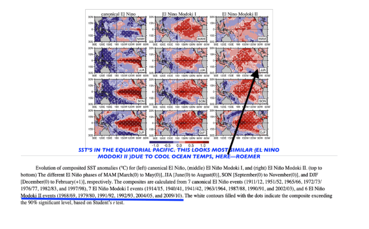
There are 3 different types of El Niño events as I show above. The cases to the far right are the most similar, in which ocean temperatures across the equatorial Pacific are warm along and west of the dateline and cool off the coast of Peru. This is fairly unusual and has only occurred in roughly 25% of all El Niño cases (1968-69; 1979-80; 1991-92; 1992-93; 2004-2005;2009-2010)
El Niño events typically lead to a cool summer across major natural gas producing areas. However, when El Niño weakens (as it is now), sometimes the above-mentioned GLAAM can become negative and result in a surge of summer heat that can affect late summer corn and soybean crops and help natural gas prices rally.
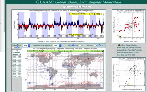
My map above shows how the United States late summer can be hotter than normal (red) when GLAAM is negative. GLAAM is a complex variable related to the earth’s spin and frictional torque. Without going into too much detail, when GLAAM is negative, we are thought to usually be in a La Niña State; positive, an El Niño State. Negative GLAAM resulted in the back to back Midwest corn and soybean droughts back in 2011-2012 and partially responsible for the “Arab Spring” and soaring grain prices in several countries that set up more warfare in the Middle East, due to famine. While not all negative GLAAM summers result in heat waves, droughts and famine, this teleconnection can still be used as guide to forecast summer weather.
BOTTOM LINE: Presently, we are in a weak EL Niño Modoki II event with a negative GLAAM that suggests EL Niño is weakening. However, due to low solar activity the effects of this El Niño Modoki II event could actually persist into the late summer and fall. There are very few cases to look at to compare these climatological variables, but I have a pretty good hunch what to look for. Usually, however, for a major summer bull market in grains and natural gas to occur from La Niña, not El Niño Modoki, needs to be present. But there are exceptions! Are we in one of those cases?
Will India’s drought get worse and finally cause sugar prices to rally? Can natural gas prices and corn and soybeans have late summer heat? If you are interested to know more and my views, please email me at subscriptionsbestweather@gmail.com


